Ketchikan

We had good weather for the passage into the port of Ketchikan, though the leaking hydraulic hose the day before was a hint of more things to break.  We cleared Customs with just a phone call – we had submitted a Float Plan via Customs’ Small Vessel Reporting Service that had all our boat and personal information, and we called ahead from Prince Rupert.  We just had to call as we were approaching the harbor to get our clearance number, and the officer told us that we were the only people to use the Float Plan system this year.

Armed with our clearance number we could proceed to the fuel dock to fill all our tanks.  When we fuel Jim operates the nozzle and I’m down in the engine room (“bilge bunny” duty) to watch the sight gauges on each of the 4 tanks.  We have 2-way radios and I let him know as we reach certain thresholds.  While we were fueling I saw that the hot water heater overflow was overflowing, and Jim told me that it sometimes happens because it’s in the engine’s water circuit (free hot water when that engine is running).  The only problem was that it kept overflowing and it should have stopped, so we had to shut off the water pump.  Which meant no water to wash our hands after fueling.  Then we tried to start the engines to leave the fuel dock and the battery switch for the engine start batteries was cracked.  Gremlins!  Jim just flipped another switch to start from the house bank and we were on our way, but we felt spooked by the sudden rash of little problems.

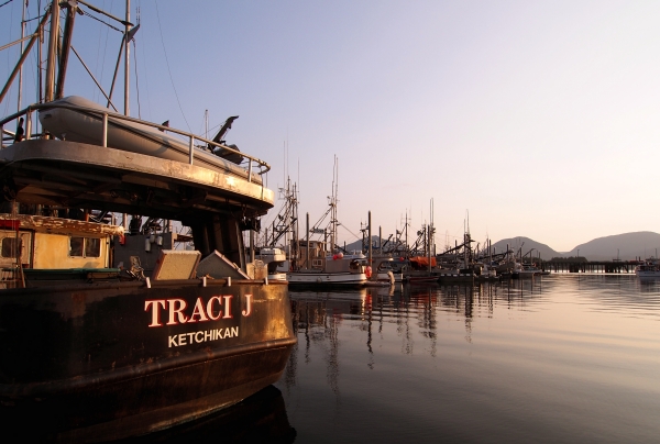
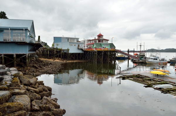
We tied up in Ketchikan’s Thomas Basin among the commercial fishing boats, with a huge cruise ship just outside the basin.  20140526_014 ketchikan jim and sign RESIZEAlthough it was a Sunday we lucked out – the hardware store was open for a few more hours so we caught the city bus and zipped up to get a new overflow valve for the hot water heater – that was the first priority so we could turn the water system back on.  We found what we needed and a spare just in case, and walked back to the boat, passing the cruise ships getting ready to depart.  It was a good way to get a little overview of the town as we walked back, but we were focused on getting the hot water heater fixed so I could finally have a shower!

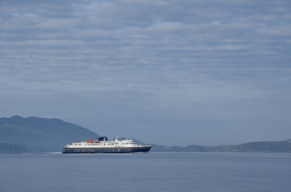
Here’s a map showing our path from Victoria, BC to Ketchikan, AK – we’ve traveled 804 nautical miles in the last 4 weeks.Victoria to Ketchikan map
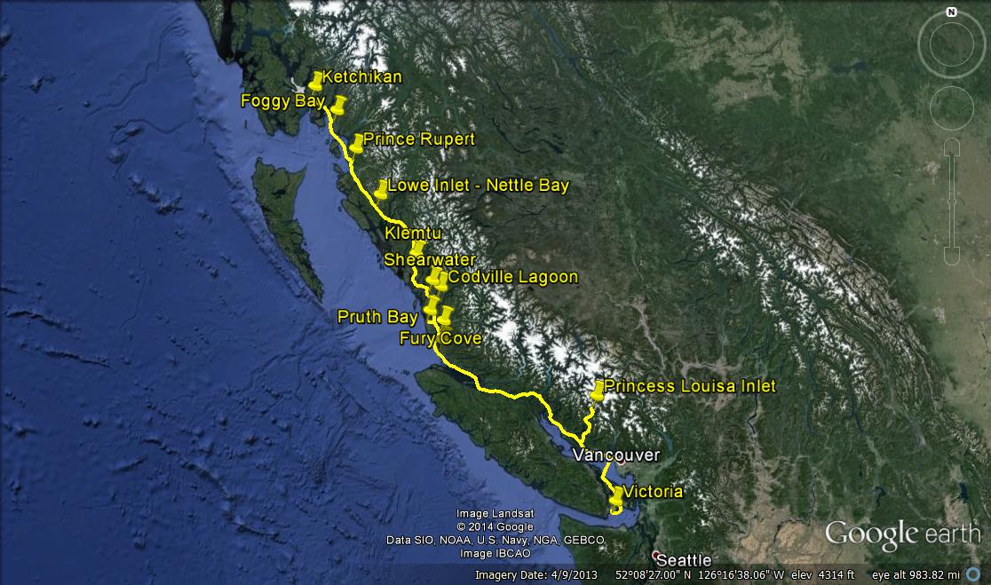
The next day was Memorial Day so we explored the town and relaxed a bit after the long days underway.  There are 3-4 cruise ships in town every day, and someone told us that there are sometimes more, so the town can be quite crowded for a while.  We watched groups heading out on kayak tours, fishing tours, high-speed catamarans going to the Misty Fjords National Monument, and float plane flightseeing tours.  In fact, we were buzzed repeatedly by a long string of float planes as we were entering the harbor – now we understand what that was all about.  When the ships leave in the afternoon the whole town breathes a sigh of relief.  The tourist shops close and the only restaurants and stores that stay open are the ones that serve the locals, which we enjoyed.  20140526_021 ketchikan creek street RESIZE20140527_029 ketchikan alaska troopers RESIZE
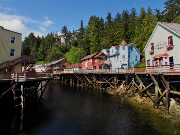
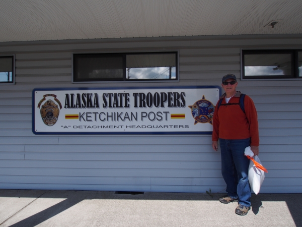
As soon as the holiday weekend was over and the marine services opened back up we hopped on the city bus to find the hydraulic shop.  The shop was located behind an Alaska State Trooper office at the other end of town, and I couldn’t resist a photo op because of the TV show…

The hydraulic guy was very nice and in just a few minutes we were on our way, though we had a long wait for the bus which only runs once an hour.  Fortunately, normally-rainy Ketchikan was enjoying a week of beautiful sunny weather and it felt great to just sit outside for a while.  On our way back to the boat we stopped at some marine stores for a few more parts for our various little repairs.  Jim fixed everything pretty quickly and we made plans to take a float plane tour of the Misty Fjords area since we don’t have time to explore it by boat right now.  We’re very excited about the flight, and the weather should be great for it.  We’ll post more about the flight in the next entry.20140527_047 ketchikan fishing boats sunset RESIZE

Goodbye Canada

The day after the gale blew through we headed into the port town of Prince Rupert – our last port of call in Canadian waters.  20140523 7606 pr shipping port RESIZEPrince Rupert is a busy place, with facilities to load cargo ships with coal, grain and containers.  It has a large fishing fleet, ferry terminal, and rail service that comes right to the docks, connecting with railroads across Canada and the U.S.  It’s not quite like coming into NY harbor, but it has been so quiet on the water lately that it was a surprise to see so much activity.  Prince Rupert is also one of the stops along the Alaskan Marine Highway – a “highway” on the water that runs from Bellingham, Washington 3,500 miles to Dutch Harbor, Alaska.20140524 7633 alaska marine highway RESIZEThis ferry route (funded partly as an interstate highway) serves many towns and cities that are not accessible by road, such as Ketchikan, Juneau, Petersburg, Sitka, etc.  We’ll take this ferry in the fall to bring our car to Petersburg, where we’ll spend the winter months aboard.

The marina in Prince Rupert was damaged by the gale the day before – they had 50+ knot winds and one of the floating docks broke – with over a dozen good-sized boats still tied to it.  Fortunately it broke inside some big pilings, and the pilings kept the chunk of dock from taking off down the waterway.  We only spent a quick overnight there because we had a great weather window to cross Dixon Entrance – the last wide open spot that requires careful planning and good conditions to transit safely.  Unfortunately we had to leave the dock at 0500, at slack tide.  We were docked broadside to the current and at 0500 it was just starting to turn to flood, which would pin us to the dock and make it very difficult to leave if we waited until a more civilized hour.  The tides are getting bigger here – this is what the marina looks like at low tide… and the ramps from the floating docks to shore get pretty steep to climb!20140523 7618 pr low tide  RESIZEWe wiggle-waggled through the narrow Venn Passage, a short cut heading north, and we were warned to follow the range marks behind us and not to trust the navigation markers because they are sometimes hit by log tows and dragged out of position.  That kind of navigation first thing in the morning is more effective than coffee, but the misty sunrise was a nice reward.20140524 7629 pr fishing boat in mist  RESIZE20140524 7634 dixon entrance mill pond RESIZEDixon Entrance was like glass, and it’s important to remember that it can get very ugly with wind, swell, and tidal outflow opposing incoming wind waves.  During the crossing Jim discovered a leaking hydraulic hose on our stabilizer pump, so we had to pin the stabilizer fins and shut the system down until we could replace the hose.  If you have to lose your stabilizers, it’s sure nice to lose them on a day like this!

We crossed the official U.S.-Canada line on the water and were very excited that we finally made it to Alaskan waters after so many years of dreaming about this.  Plenty of people have been making this trip in all kinds of boats for ages – it’s not that big of a deal, except when you start out living on the land in Virginia and dreaming about someday getting a boat and taking it to exotic and interesting places.  We dreamed and saved and prepared for 15 years before we were able to buy our ADVENTURES, and then more years getting her (and us!) updated and ready for extended cruising.  We would get these ideas about places we wanted to take her – we call them “pictures on the refrigerator” – and it’s a very wondrous thing when a wild idea comes off the refrigerator and slides under the keel.

We were bound for Ketchikan, the U.S. port of entry, but it’s a bit far from Prince Rupert for slower cruising boats, so we made arrangements with U.S. Customs to anchor in Foggy Bay for the night.  Foggy Bay was a beautiful cove, though the entrance is very narrow and the chart is not accurate – you have to watch the depths and read the water.  We were greeted by a bald eagle sitting proudly in a tree at the entrance to the cove, and after we were anchored and had a nap we watched a black bear munching on grasses on the shore.  He was around in the late afternoon, and came out again in the morning when we pulled anchor and headed out.  He looked up briefly at the sound of the anchor chain rattling, but then went back to his breakfast.20140524 7572 foggy bay bear 3 RESIZE

Waterfalls and Weather

As we travel through the rabbit’s warren of channels that comprise the Inside Passage, the navigational chart shows nearly sheer shorelines for the vast majority of our travels – mountains that plunge directly into the sea, with water depths commonly 1000′ or deeper.20140523 7594 grenville channel  RESIZE We’ve seen some bigger hills that have the word “cone” in their name.  I’ll have to look up more information about the geology of this region, but these formations certainly look like very old volcanic cones now covered in a thick layer of evergreen trees.  We’re cruising through a number of long, fairly straight channels, the PNW equivalent of the Atlantic Intracoastal Waterway (ICW) in a way, but these channels are very deep where the ICW is very shallow.  There are very few anchorages in this area because it’s so deep right up to the steep shoreline, but there are waterfalls EVERYWHERE!  Tall ones, short ones, wide ones and narrow ones – all roaring today as we cruise on by.  It’s too rainy to get really good photos, but if we tried to photograph them all we’d do nothing but run from one side of the boat to the other.20140521 7584 grenville waterfall vertical  RESIZEAt this point we’re taking advantage of some rainy weather to just make miles – we plan to spend time in this part of BC later on, but right now we need to stay focused on getting to SE Alaska.  By the end of today we’ll be about 120 nautical miles south of Ketchikan, and the closer we get the more exciting it is.  It’s a “pilothouse” kind of day – where we’re warm and snug and comfortable in the boat despite the misty-rainy cool weather outside.  20140523 7587 pulling anchor in the rain  RESIZE

It’s not fun setting and retrieving the anchor in this kind of weather, but it doesn’t take very long and the rest of the time underway we can take turns running the boat and watching for logs and wildlife.  Once in a while we get a little surprise on the anchor chain – the sun starfish seem to like to clamp on, and they only let go when they get to the surface.  We’ve found these hitchhikers a few times now.20140519 7363 sunstar on anchor chain  RESIZEWe anchored in Lowe Inlet, halfway up the long and narrow Grenville Channel for the night and to wait out some ugly weather for a day.  There is a small but dramatic waterfall at one end of the anchorage, but the best holding is around the corner from the waterfall so we chose security over scenery and anchored well in 101′ of water – a big first for us!  We are growing accustomed to the deeper anchorages here in the PNW, but 101′ is quite deep and we’re glad we got a longer anchor chain last fall.  We had the anchorage all to ourselves, and we spent a rainy Thursday getting lashed by hard rain and gusty winds, even tucked as far back as we were.  We saw a peak gust of 37 knots, but the anchor held just fine and we got the chance to catch up on some trip planning.  We got a quick look at Verney Falls as we were pulling out of the anchorage – it was really roaring with all the rain.20140523 7590 verney falls  RESIZE

Tiny Towns and Entertaining Wildlife

Not far from Codville Lagoon are the twin towns of Bella Bella and Shearwater.  I’m not sure why there are two towns almost across from one another, but both sell fuel and that is the primary reason for us to stop.  We wanted to take on about 150 gallons of diesel to give us a larger reserve to get to Ketchikan, where we’ll fill all the tanks at lower U.S. prices.
We heard that the little store and restaurant/cafe at Bella Bella had been damaged in a fire, so we headed to the much smaller (but better equipped) Shearwater.  Unfortunately we forgot to look at the calendar – it was a Canadian holiday, Victoria Day, so most things were closed except (thank goodness!) the restaurant.  THE restaurant.  The whole town is about 200 yards long, on one gravel street.  There is a small boat yard with a 70 ton lift – the only lift available within a few hundred miles, a marine store, grocery, gift shop, laundromat, and a couple of small inns for people who come here to fish or go on eco-tours to see wildlife and whales.  20140519 7381 shearwater main street  RESIZEThere is a little ferry that runs between the two towns (the Shearwater SeaBus), and it carries the Shearwater children to school in Bella Bella as well as more typical ferry duties throughout the day.  At dinner we met the owner of the property, enjoying the stories about his grandfather coming from Norway to settle in the area.  The owner bought the place from his father at age 29 and has been running it ever since – he’s now in his 70s.  He has even created a small memorial to local residents lost in wars, as well as the site’s former life as a seaplane base in WWII.20140519 7380 shearwater commemorative totem  RESIZEWe lucked out and met some friendly cruisers on the dock in Shearwater to talk to.  We met one of the couples last summer in the Broughtons and they’re interesting – retired school principals; the wife has written several novels.  Her newest book is set in Petersburg, Alaska where we’ll be spending this coming winter, so we added her book to our e-readers for a bit of local flavor.  In general we haven’t encountered too many overtly friendly people along the way – the PNW culture seems to be more reserved so it often takes more time for people to warm up to conversation.  Since Jim and I spend 24 hours a day in close quarters together we’re always glad to have new humans to talk to and we’re grateful when we meet outgoing people.
20140520 7403 cruise ship volendam RESIZEHeading north out of Shearwater we are cruising through protected waters most of the time – hence the name “the Inside Passage”.  Compared to cruising through the Atlantic ICW the Inside Passage seems very lightly traveled – there are fishing boats, ferries, and the occasional cruise ship – though it’s often that we only see two or three other boats all day.

As we were cruising up the broad Finlayson Channel we saw a great deal of splashing ahead of us.  Jim and I ran to the bow and we saw over a dozen black and white Dall’s porpoises zooming around in our bow wake, much faster and more athletic than any of the many encounters we’ve had with dolphins on the east coast.  20140520 7521 dalls porpoise  RESIZEThe porpoises don’t jump out of the water like dolphins do, instead they slice the water’s surface, moving so quickly that they leave a big rooster-tail wave to mark their passage.  They entertained us for about 15 minutes, and then vanished.  It was a high-octane encounter that left us very excited – wow!


We made a brief stop in the First Nations town of Klemtu to see their Big House and its totems.  20140520_008 klemtu big house welcome totem RESIZE20140520_004 klemtu big house RESIZEOn occasion the town holds dancing and drumming shows in the Big House, and we were sad that our visit was too early in the season to experience one.  20140520 7535 klemtu totem wolf  RESIZEOur guide, George, was very nice and we enjoyed hearing about the close-knit community of 500 people, a combination of 4 regional tribes.  We stopped at the little grocery store in town and got the next to last package of lettuce and two small rocks disguised as tomatoes – the best luck with produce is right after the ferry comes in with supplies once or twice a week.  The little town has a salmon cannery, but it’s for the farm-raised Atlantic salmon produced by the very controversial aquaculture facilities in the area.  I find it odd to see the First Nations people, typically so spiritual and close to the fish and creatures that comprise their traditional foods, supporting aquaculture that threatens the health of the wild salmon that’s so important to this entire region.