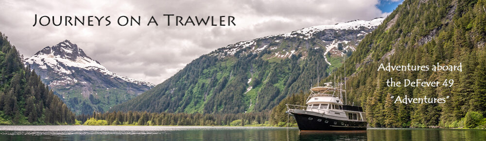
Holidays in the Keys – January 11, 2013
|
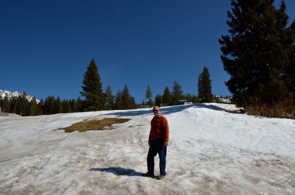
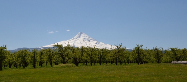
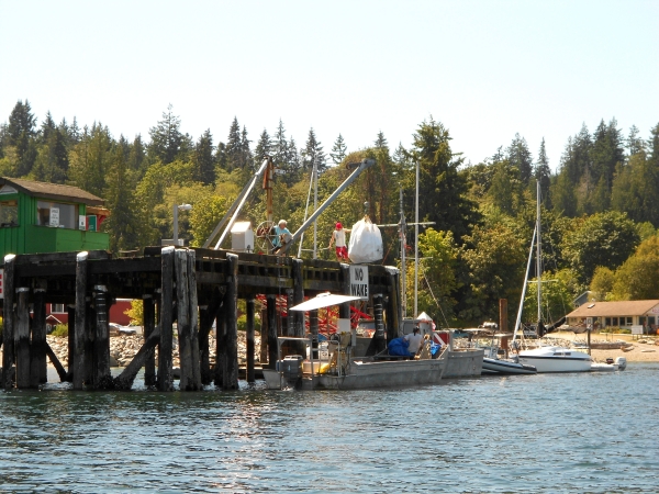
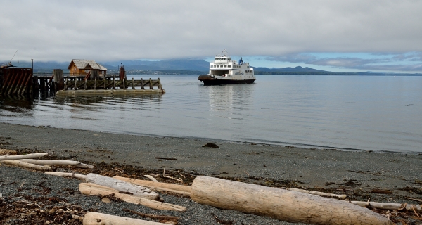
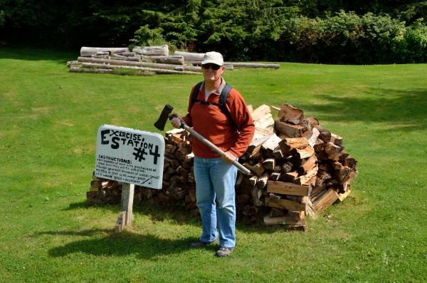
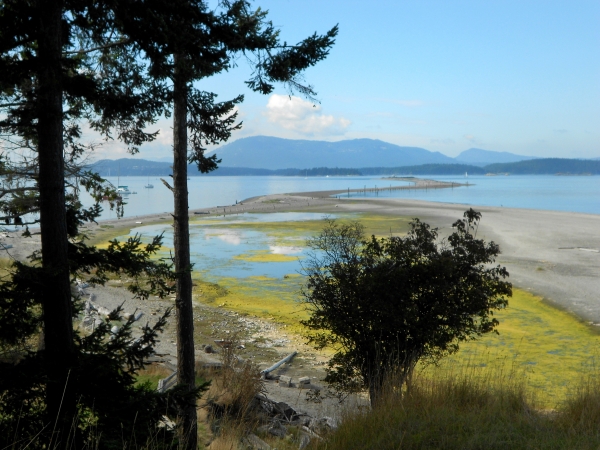
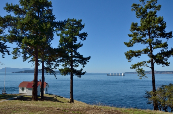
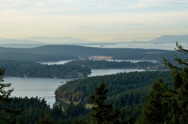
We had a great cruise into our beloved Florida Keys. We anchored behind Pumpkin Key next to the very exclusive Ocean Reef Club at the north end of Key Largo so we could jump out to the ocean side of the Keys for the rest of the trip to Marathon. The path to Hawk Channel is through Angelfish Creek which has notoriously shifting shoals at the mouth. We had to transit it at the top of high tide, and our reward was a beautiful Keys sunrise as we got to the ocean. We had a nice cruise down Hawk Channel, though it’s important to keep a sharp watch out for crab pots! The floats they use here in the Keys are pretty small and they can be hard to see until they are close. Hawk Channel is fairly shallow – 15-25′ on average. It runs on the inside of the reef so it has better protection from ocean waves; on the outside of the reef the depths drop off dramatically and the Gulf Stream current often comes very close to the edge.The Keys are about 100 miles long – a chain of islands connected by bridges first built by Henry Flagler for his Overseas Railroad in the early 1900’s. We had a nice cruise down Hawk Channel, though it’s important to keep a sharp watch out for crab pots! The floats they use here in the Keys are pretty small and they can be hard to see until they are close. Hawk Channel is fairly shallow – 15-25′ on average. It runs on the inside of the reef so it has better protection from ocean waves; on the outside of the reef the depths drop off dramatically and the Gulf Stream current often comes very close to the edge.The Keys are about 100 miles long – a chain of islands connected by bridges first built by Henry Flagler for his Overseas Railroad in the early 1900’s. No trip to Marathon would be complete without a storm. We ALWAYS seem to get a little storm just to make things interesting. This year it was only a series of smaller rain squalls, but they passed very near us and made it a little exciting. As we approached Sombrero light we could see the closest dark clouds and rain.We dodged the weather and tucked into our usual slip well before sunset. We have the nicest view of the sun setting into the ocean right from our slip, and sometimes we get lucky enough to see a green flash (if the conditions are right). No trip to Marathon would be complete without a storm. We ALWAYS seem to get a little storm just to make things interesting. This year it was only a series of smaller rain squalls, but they passed very near us and made it a little exciting. As we approached Sombrero light we could see the closest dark clouds and rain.We dodged the weather and tucked into our usual slip well before sunset. We have the nicest view of the sun setting into the ocean right from our slip, and sometimes we get lucky enough to see a green flash (if the conditions are right). Early December is the usual time for the various holiday boat parades, and we enjoyed the small but enthusiastic parade that passed right by our marina. Early December is the usual time for the various holiday boat parades, and we enjoyed the small but enthusiastic parade that passed right by our marina. 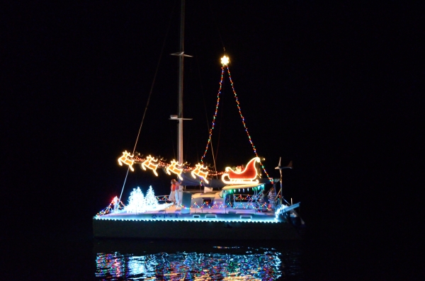 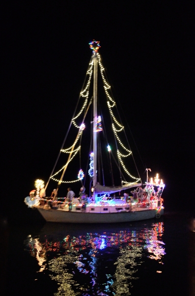 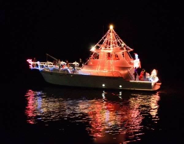 We got into the spirit of it all and Jim outlined ADVENTURES in lights, and I put up a lot of our little decorations. We got into the spirit of it all and Jim outlined ADVENTURES in lights, and I put up a lot of our little decorations.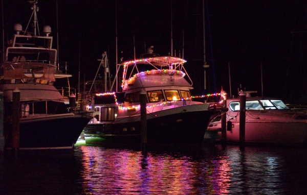  We’ve had a bit of excitement around here – some Cuban refugees made landfall by climbing on a neighbor’s boat and then scrambling up onto the dock, and another group abandoned their “chug” in the mangroves nearby. It’s scary to think about how too many people jammed into a homebuilt boat like this can safely make the 90 mile trip across the Florida Straits. So many do not succeed, and some are found by the Coast Guard and brought back to Cuba.A good friend had a bad fall off the dock and broke his leg. And the marina’s general mgr. was arrested for drug smuggling and attempted murder-for-hire. There’s always something interesting going on around here! We’ve had a bit of excitement around here – some Cuban refugees made landfall by climbing on a neighbor’s boat and then scrambling up onto the dock, and another group abandoned their “chug” in the mangroves nearby. It’s scary to think about how too many people jammed into a homebuilt boat like this can safely make the 90 mile trip across the Florida Straits. So many do not succeed, and some are found by the Coast Guard and brought back to Cuba.A good friend had a bad fall off the dock and broke his leg. And the marina’s general mgr. was arrested for drug smuggling and attempted murder-for-hire. There’s always something interesting going on around here! |
ADVENTURES Next Adventures – April 20, 2013 |
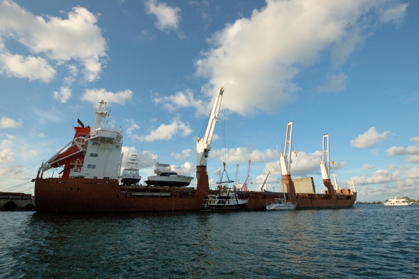
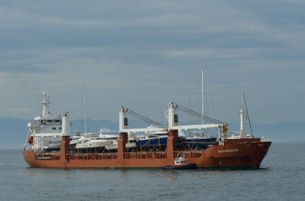
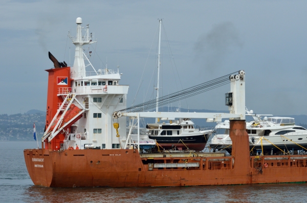
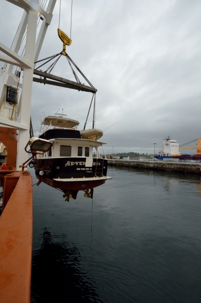
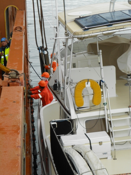
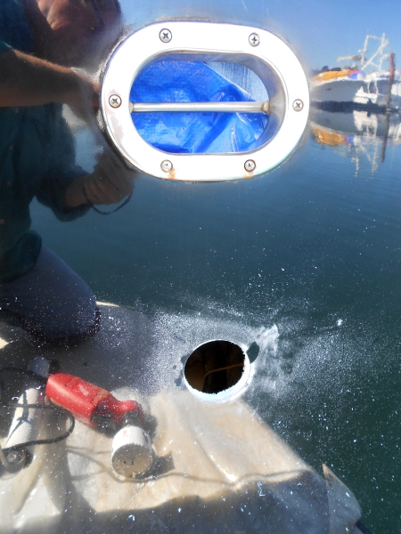
There are many stories and photos from this winter season in Marathon that we want to catch up on, but…The big news to report is that ADVENTURES has been safely loaded aboard the 450′ Dutch freighter EUROGRACHT in the Port of Palm Beach for her journey through the Panama Canal and up to Victoria, BC, Canada. This is the ship approaching Lake Worth inlet.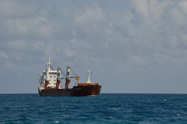 She’s due to arrive in Victoria around May 9th and we’re driving across country to meet her and to begin some years of cruising in the beautiful Pacific Northwest. She’s due to arrive in Victoria around May 9th and we’re driving across country to meet her and to begin some years of cruising in the beautiful Pacific Northwest.Preparing our only home for a big ocean journey is a daunting task – we worked for about a week to get everything lashed down, stowed, secured, and ready.On Wednesday afternoon we drove ADVENTURES to the side of the EUROGRACHT and watched the loadmasters bring lots of heavy straps aboard and then position the wide lifting straps from one of the ship’s cranes. 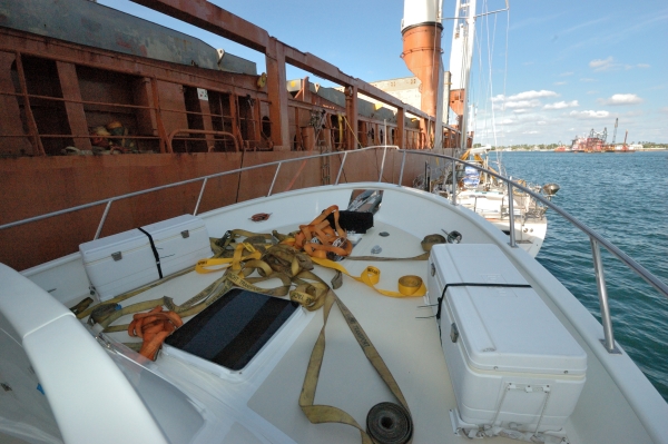 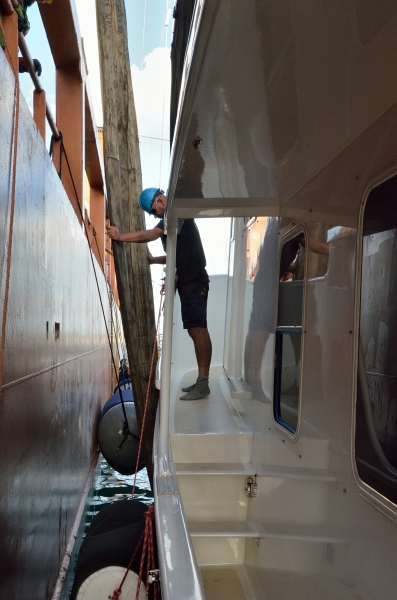 Divers were in the water to help position the huge lifting straps under the hull and make sure they were clear of the stabilizer fins. At the last minute we had to lower 6 antennas so they would clear the overhead lifting bar. Once everything was ready for lifting we boarded a small launch and waited near the ship to watch her get settled on deck. Divers were in the water to help position the huge lifting straps under the hull and make sure they were clear of the stabilizer fins. At the last minute we had to lower 6 antennas so they would clear the overhead lifting bar. Once everything was ready for lifting we boarded a small launch and waited near the ship to watch her get settled on deck.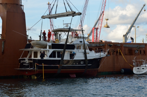 We’ve seen our boat hauled out of the water for maintenance periodically, but it’s a different feeling watching our home lifted high out of the water an onto the deck of a ship! We’ve seen our boat hauled out of the water for maintenance periodically, but it’s a different feeling watching our home lifted high out of the water an onto the deck of a ship!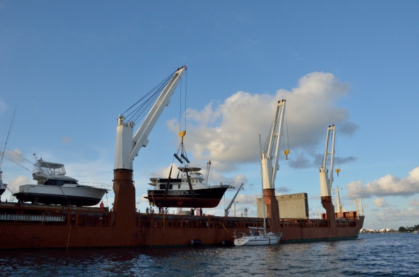 On Thursday we were allowed back into the Port and aboard the ship so we could put the antennas back up – the loadmaster told us the antennas would ride better upright. On Thursday we were allowed back into the Port and aboard the ship so we could put the antennas back up – the loadmaster told us the antennas would ride better upright.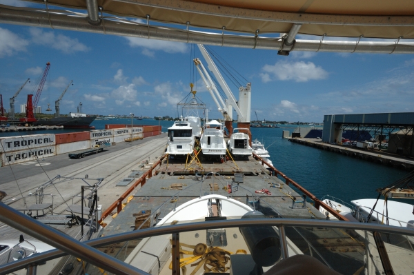 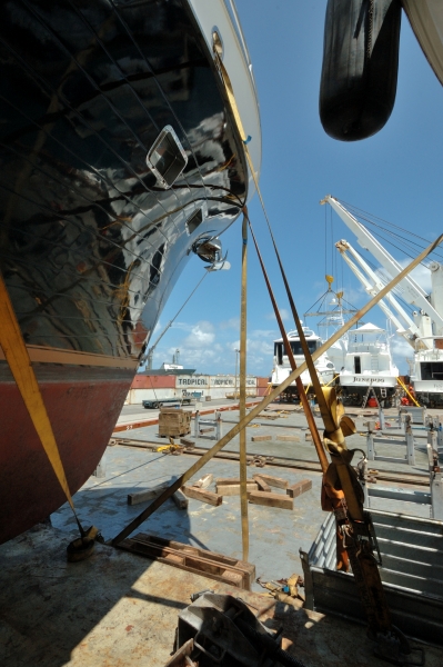 It was very interesting to get aboard and see the deck full of more boats, and the welded cradles and stands, and all the straps holding boats to the deck. The crew had still not finished installing the spiderweb of straps, but it’s a pretty impressive operation.The EUROGRACHT finally departed around midnight on Thursday, heading for the Panama Canal. We have a long drive ahead of us, and we’ll use that time to catch up on the blog from our busy winter. We’ll also be watching the weather to see what the EUROGRACHT and ADVENTURES are experiencing. Victoria, here we come! It was very interesting to get aboard and see the deck full of more boats, and the welded cradles and stands, and all the straps holding boats to the deck. The crew had still not finished installing the spiderweb of straps, but it’s a pretty impressive operation.The EUROGRACHT finally departed around midnight on Thursday, heading for the Panama Canal. We have a long drive ahead of us, and we’ll use that time to catch up on the blog from our busy winter. We’ll also be watching the weather to see what the EUROGRACHT and ADVENTURES are experiencing. Victoria, here we come! |
|
|||||||||||||||||||||
|
|||||||||||||||||||||
|
|||||||||||||||||||||
Pacific Northwest Hazards – July 7, 2013 |
|||||||||||||||||||||
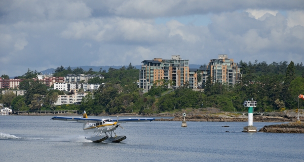
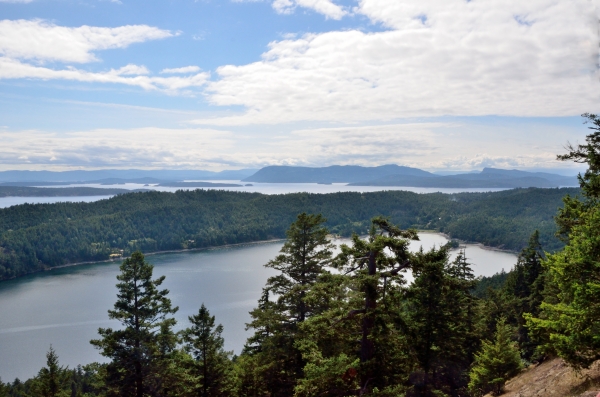
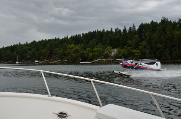
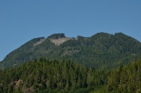
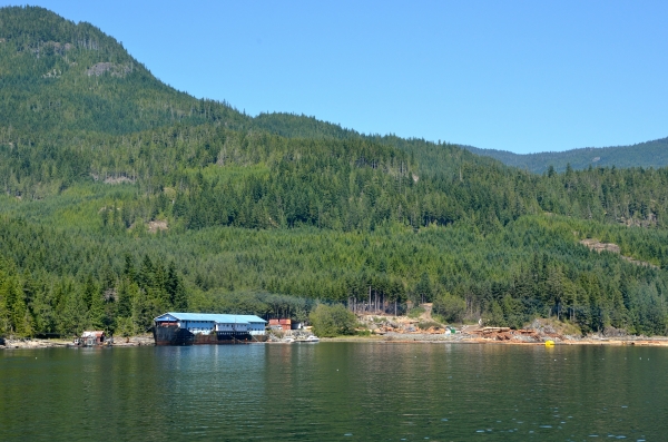
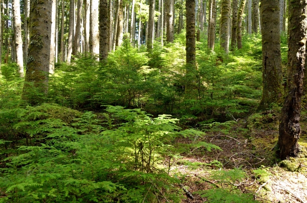
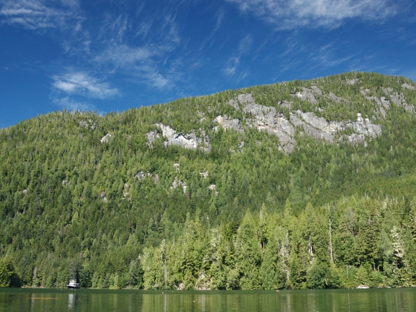
The Gulf Islands off Vancouver Island are very pretty, and we’ve spent a wonderful three weeks exploring small towns and hiking various parks. There are a lot of new things we have to get used to out here, such as logs. There is a lot of logging and log handling along the Inside Passage, and a lot of logs get loose. They can be quite large and you don’t want to hit one!We’ve seen several towns with some kind of log handling operation – wood pulp or lumber mill or shipping, and large natural bays can be full of corraled floating logs…and long log booms towed by tugs. There are a lot of new things we have to get used to out here, such as logs. There is a lot of logging and log handling along the Inside Passage, and a lot of logs get loose. They can be quite large and you don’t want to hit one!We’ve seen several towns with some kind of log handling operation – wood pulp or lumber mill or shipping, and large natural bays can be full of corraled floating logs…and long log booms towed by tugs.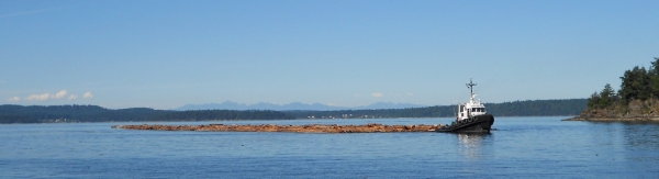 Another new thing to get used to and to watch out for are seaplanes. They are everywhere, with scheduled flights to/from small towns as well as frequent visits to many other harbors. We have learned to keep a sharp eye out for seaplanes landing when we’re out in the dinghy since they are pretty quiet when they land. Taking off is a noisy affair so we get plenty of warning. Planes land in the same channels that boats use, and we’ve seen them take off and land fairly close to us or other boats. It’s just how things are done around here, and everyone seems to deal with it without much fuss. Some time we’ll take a flight on one – it looks like so much fun!Last week we anchored in Tod Inlet so we could visit the famous Butchart Gardens near Victoria. They have a nice dinghy dock for boaters to access, and we got a kick out of the sign on the end of the dock…A little something for everyone – how thoughtful! Another new thing to get used to and to watch out for are seaplanes. They are everywhere, with scheduled flights to/from small towns as well as frequent visits to many other harbors. We have learned to keep a sharp eye out for seaplanes landing when we’re out in the dinghy since they are pretty quiet when they land. Taking off is a noisy affair so we get plenty of warning. Planes land in the same channels that boats use, and we’ve seen them take off and land fairly close to us or other boats. It’s just how things are done around here, and everyone seems to deal with it without much fuss. Some time we’ll take a flight on one – it looks like so much fun!Last week we anchored in Tod Inlet so we could visit the famous Butchart Gardens near Victoria. They have a nice dinghy dock for boaters to access, and we got a kick out of the sign on the end of the dock…A little something for everyone – how thoughtful! Tod Inlet was a beautiful spot that felt very remote, despite being about 10 km from downtown Victoria. Tod Inlet was a beautiful spot that felt very remote, despite being about 10 km from downtown Victoria.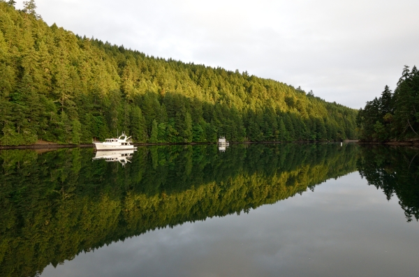 We had cocktails with some local boaters and they warned us about some troublesome otters in the area. Just as a precaution we closed the side gate to the boat, and it was a good thing since the otters had a big party on our swim platform and in our dinghy overnight. We never heard them, but they left fish guts and other smelly messes for us. We used to think that otters were cute, but after cleaning more fish guts off our swim platform again this morning they are Public Enemy #1!The Butchart Gardens were stunning, and we spent a very long day photographing the incredible variety of flowers around the property. We’re feeling more like locals now – we bought annual passes for the Gardens since we plan to winter in nearby Victoria. I’ll post more about Butchart Gardens in the next blog entry. We had cocktails with some local boaters and they warned us about some troublesome otters in the area. Just as a precaution we closed the side gate to the boat, and it was a good thing since the otters had a big party on our swim platform and in our dinghy overnight. We never heard them, but they left fish guts and other smelly messes for us. We used to think that otters were cute, but after cleaning more fish guts off our swim platform again this morning they are Public Enemy #1!The Butchart Gardens were stunning, and we spent a very long day photographing the incredible variety of flowers around the property. We’re feeling more like locals now – we bought annual passes for the Gardens since we plan to winter in nearby Victoria. I’ll post more about Butchart Gardens in the next blog entry. |
|||||||||||||||||||||


Gardens, Vineyards, and Friends – July 14, 2013 |
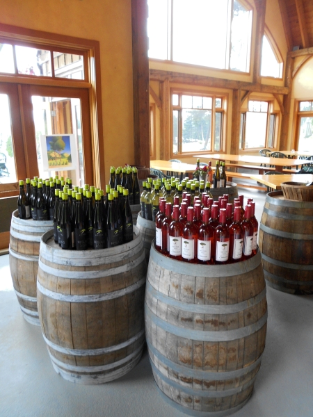
Our friend Laurie from grad school came up to visit us, and we had a great time exploring some of the Gulf Islands. We all enjoy photography so we had to spend a long day at the famous Butchart Gardens near Victoria.  It’s an amazing place with many different types of gardens, including a stunning rose garden……and a huge sunken garden. It was a cloudy day – perfect for close-up flower photography, but not the best for wide angle shots of this fantastic place. It’s an amazing place with many different types of gardens, including a stunning rose garden……and a huge sunken garden. It was a cloudy day – perfect for close-up flower photography, but not the best for wide angle shots of this fantastic place.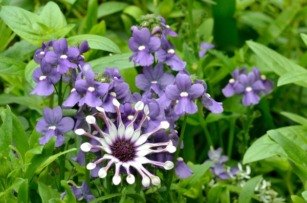 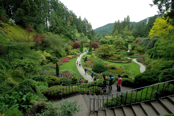 We cruised to Saturna Island to visit the little winery again. We cruised to Saturna Island to visit the little winery again.  Their little bistro was scheduled to open, and we liked the chardonnay grown in the shadow of a huge cliff face – it’s the big expanse of rock heated by the sun that keeps the grapes warm. We enjoyed the bistro and bought a few more bottles of wine, and noticed that even the locals think the new chef at the bistro has done a good job!We spent some time hiking around Montague Bay where there’s a Provincial Park, and saw a nice sandy beach where the Canadians were actually swimming – the water is about 60 degrees! Their little bistro was scheduled to open, and we liked the chardonnay grown in the shadow of a huge cliff face – it’s the big expanse of rock heated by the sun that keeps the grapes warm. We enjoyed the bistro and bought a few more bottles of wine, and noticed that even the locals think the new chef at the bistro has done a good job!We spent some time hiking around Montague Bay where there’s a Provincial Park, and saw a nice sandy beach where the Canadians were actually swimming – the water is about 60 degrees! We are acclimating to the cooler temps up here, but will never jump into water that cold without a heavy wet suit or a dry suit on! We are acclimating to the cooler temps up here, but will never jump into water that cold without a heavy wet suit or a dry suit on! We strolled the streets of Ganges, a little town on Salt Spring Island known for its artsy community. We’ve had a nice mix of towns as well as woods and hiking, though I really love the wild places and am looking forward to heading north to Desolation and the Broughtons. We strolled the streets of Ganges, a little town on Salt Spring Island known for its artsy community. We’ve had a nice mix of towns as well as woods and hiking, though I really love the wild places and am looking forward to heading north to Desolation and the Broughtons.
July 1 is Canada Day, and we anchored off South Pender Island to watch the fireworks. It wasn’t quite the same as a good old Fourth of July, but we had a great view from the bow of our boat. We had a great time with Laurie, and the fireworks were a nice finale to her trip. While we’re savoring the beauty of our new cruising grounds, we think about our friends who are struggling with serious health issues. We never take a day of any of this for granted, and we try to live as best we can every day since one never knows what will happen tomorrow. Our thoughts and prayers are with those dealing with difficulty and sadness. |
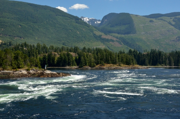
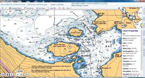
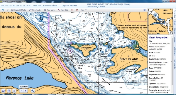
Skookumchuck Rapids – July 14, 2013 |
|
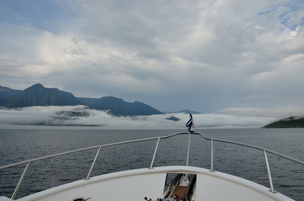
We crossed the Strait of Georgia from Vancouver Island (where the city of Vancouver is NOT) over to the mainland (where Vancouver IS) to explore British Columbia’s Sunshine Coast and Desolation Sound. About 50 miles NW of Vancouver (the city, not the island) is one of the areas where a narrow cut causes violent rapids and whirlpools to form when the tidal current is at its strongest. Friends recommended a little marina where we could tie up and hike to an overlook to watch Skookumchuck Rapids (aka “the Skook”). But first, we had to head north up Agamemnon Channel towards the area where the Skook occurs, and turning the corner into the channel was just breathtaking. And of course a bald eagle flew across our path, just to add to the dramatic view.
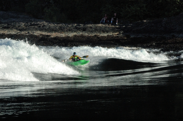
Pictures just don’t do justice to the roaring, rushing water that was moving at speeds up to 16 knots. Yet this rapids is as placid as a mill pond at slack current, and boats like ours can make the passage through it easily – though the window for slack is about 15-20 minutes. Scary! We made arrangements to take a fast tour boat through the rapids at maximum flood later in the day – just to experience it for ourselves. On the flood tide the current produces huge standing waves (12-15′ tall) and the local white water kayakers take turns paddling into those monsters and doing spin tricks. Amazing.
We enjoyed some nice cold beer watching the mountains change from golden-green to deep blue and purple as the sun set.
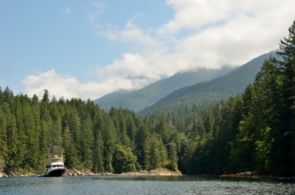
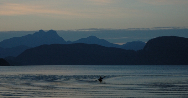
In the morning this was our view, with ONE FINE DAY just a white speck as we headed to our next destination: Princess Louisa Inlet. |

Princess Louisa Inlet – July 24, 2013 |
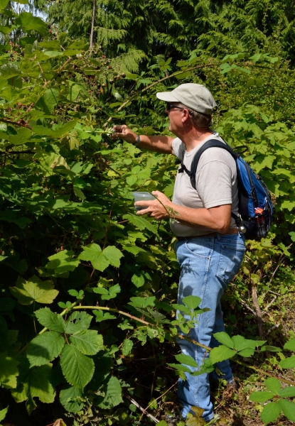
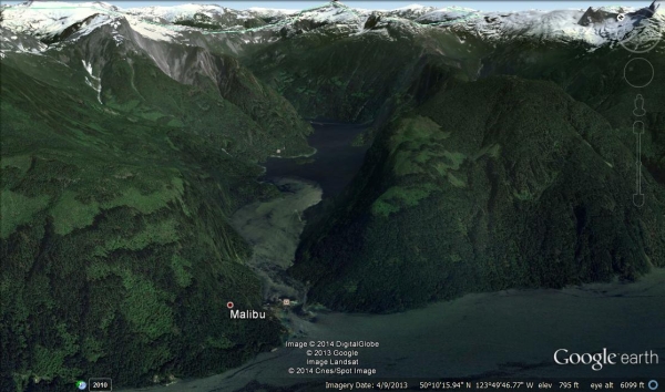 Take a look at Princess Louisa Inlet on Google Earth – it’s up a series of fjords that reach deep into Canada’s Coastal Mountains. Accompanied by ONE FINE DAY, we made the long 50 mile trek up to Princess Louisa – a place only accessible by boat or seaplane – and it was well worth the trip. When I say fjords, I mean mountains that are 4500-7000′ tall that plunge straight down into water that is a thousand or more feet deep. Take a look at Princess Louisa Inlet on Google Earth – it’s up a series of fjords that reach deep into Canada’s Coastal Mountains. Accompanied by ONE FINE DAY, we made the long 50 mile trek up to Princess Louisa – a place only accessible by boat or seaplane – and it was well worth the trip. When I say fjords, I mean mountains that are 4500-7000′ tall that plunge straight down into water that is a thousand or more feet deep. Just before entering Princess Louisa, you have to wiggle through the tight S-curve of Malibu Rapids (at slack current, of course). As Princess Louisa Inlet opens up you almost can’t catch your breath. Words are woefully inadequate to describe it. At the head is the biggest waterfall, Chatterbox Falls, which sits beneath a huge vertical granite cliff face. The ranger told us that mountain goats raise their kids on that cliff face in the spring. Just before entering Princess Louisa, you have to wiggle through the tight S-curve of Malibu Rapids (at slack current, of course). As Princess Louisa Inlet opens up you almost can’t catch your breath. Words are woefully inadequate to describe it. At the head is the biggest waterfall, Chatterbox Falls, which sits beneath a huge vertical granite cliff face. The ranger told us that mountain goats raise their kids on that cliff face in the spring.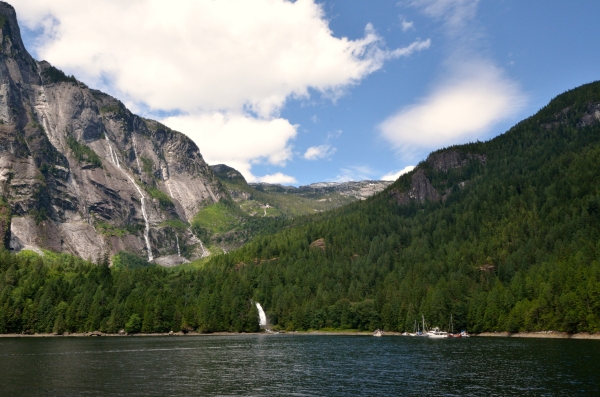 You can see how tiny the boats look in the lower right, just to give you some sense of scale, though the photos don’t capture the grandeur. White ribbons of falling water are all around, 60+ waterfalls when the snow melt is at its most active in the spring. We spent a glorious three nights on the park dock there, though you can stay longer and anchor in a few spots near other little waterfalls. The water is very deep so you just drop an anchor and a lot of chain close to shore and stern tie to shore. We definitely plan to return more than once! You can see how tiny the boats look in the lower right, just to give you some sense of scale, though the photos don’t capture the grandeur. White ribbons of falling water are all around, 60+ waterfalls when the snow melt is at its most active in the spring. We spent a glorious three nights on the park dock there, though you can stay longer and anchor in a few spots near other little waterfalls. The water is very deep so you just drop an anchor and a lot of chain close to shore and stern tie to shore. We definitely plan to return more than once!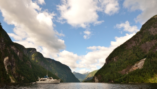 As you can imagine, there is no cell service or TV signal way up here, but it’s good to savor the beauty without distractions. As you can imagine, there is no cell service or TV signal way up here, but it’s good to savor the beauty without distractions.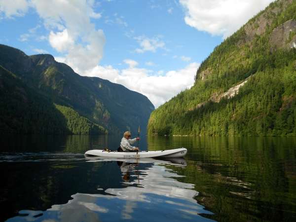 While Linda and I paddled kayaks, Jim and our friend Ed went on a long hike up to the trapper’s cabin high up the mountainside. Along the way they found some nice huckleberries and wild blueberries……though they were exhausted by the very vertical scramble. While Linda and I paddled kayaks, Jim and our friend Ed went on a long hike up to the trapper’s cabin high up the mountainside. Along the way they found some nice huckleberries and wild blueberries……though they were exhausted by the very vertical scramble.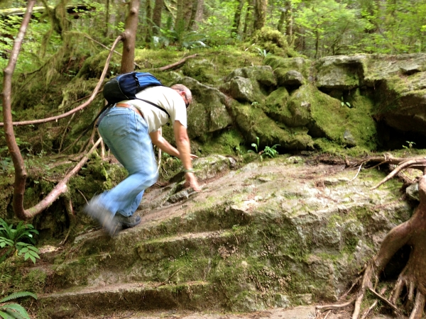  Such a special place deserved a more formal touch for dinner, so we set a proper table on the park dock with our buddy boat friends. To top it all off, Linda and Ed served crepes with sauce made from the berries for dessert. Such a special place deserved a more formal touch for dinner, so we set a proper table on the park dock with our buddy boat friends. To top it all off, Linda and Ed served crepes with sauce made from the berries for dessert. 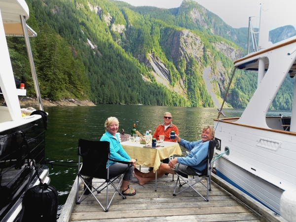 We’ll return in the spring when Chatterbox Falls is roaring! We’ll return in the spring when Chatterbox Falls is roaring! |
More Desolation Sound – July 28, 2013 |
||
 Our next stop was Prideaux Haven, which has several coves and rock crannies where boats can anchor. We chose Melanie Cove for this visit, but we’ll try other spots on future visits because each has a different view. Our next stop was Prideaux Haven, which has several coves and rock crannies where boats can anchor. We chose Melanie Cove for this visit, but we’ll try other spots on future visits because each has a different view.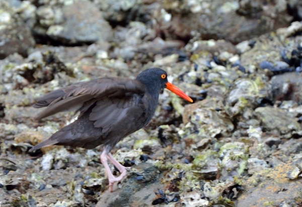 Our cove had a little babbling brook where I found a nice black oystercatcher hunting in the shallows.It was a terrific place to kayak with so many little corners to explore and beautiful views.Boats were able to anchor in some improbable spots by using a stern tie – a line from the stern of the boat tied to something sturdy on shore. We bought a big reel of line in case we need to stern tie, but we haven’t tried it yet. It’s another Pacific NW custom we’re learning about. Our cove had a little babbling brook where I found a nice black oystercatcher hunting in the shallows.It was a terrific place to kayak with so many little corners to explore and beautiful views.Boats were able to anchor in some improbable spots by using a stern tie – a line from the stern of the boat tied to something sturdy on shore. We bought a big reel of line in case we need to stern tie, but we haven’t tried it yet. It’s another Pacific NW custom we’re learning about.
We decided to go to the music festival since we have bikes. We knew the island was very hilly, but the exercise is good for us! It turned out that the hills were much steeper than we expected, and we walked our bikes up the worst ones. But the ride on the road through the deep forest was very beautiful. We arrived a little after the music festival was due to start and found a bunch of hippies making signs and cutting the grass… the stage was set up but it didn’t look like music was going to happen anytime soon. The whole thing was a little creepy so we took a short break to rest, and got back on the hilly road for the 8 km ride/walk. An adventure! |

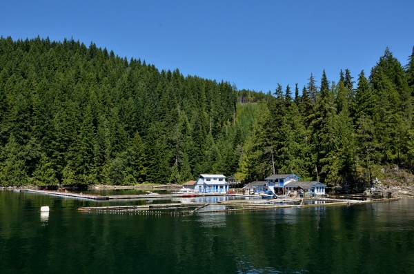
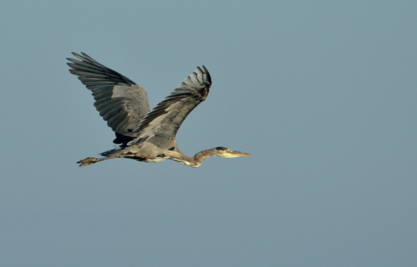
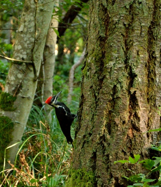
Welcome to the Broughtons – August 19, 2013 |
||||||
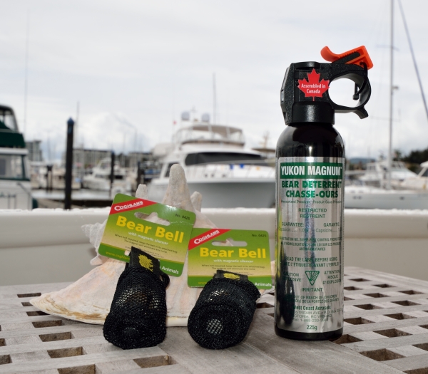
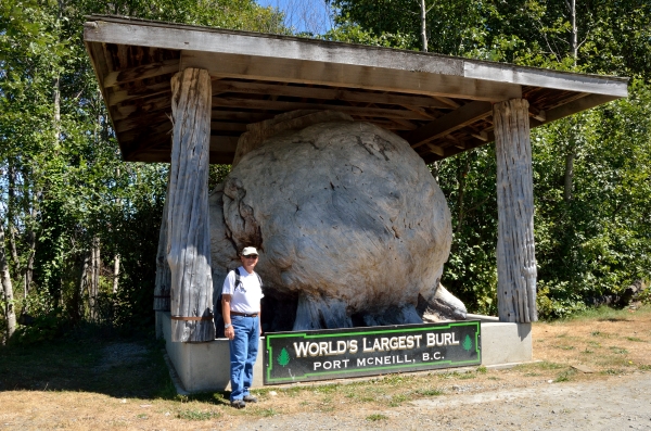
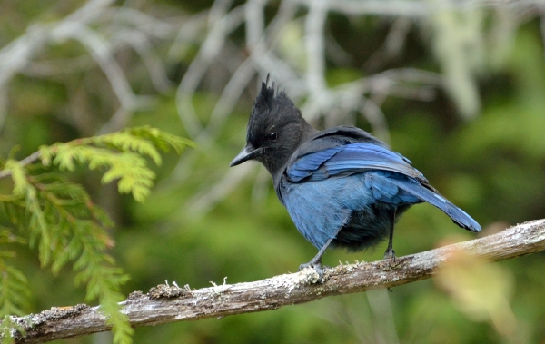
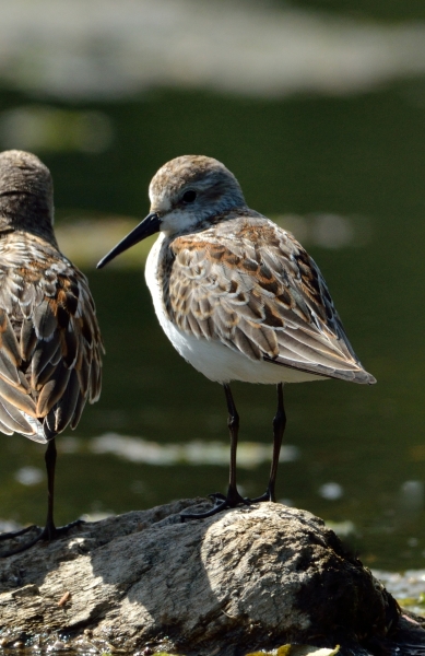
 The Broughtons is the name of a group of islands and channels off the BC mainland, across from Port McNeill. It’s a bit cooler and subject to more changeable weather since it’s exposed to the Pacific Ocean from the northwest, but it is more remote and very interesting and beautiful! We cruised across through some patchy fog, and were heading across a bay towards our first anchorage when we spotted our first orcas – what a thrill! The Broughtons is the name of a group of islands and channels off the BC mainland, across from Port McNeill. It’s a bit cooler and subject to more changeable weather since it’s exposed to the Pacific Ocean from the northwest, but it is more remote and very interesting and beautiful! We cruised across through some patchy fog, and were heading across a bay towards our first anchorage when we spotted our first orcas – what a thrill! It looked like a small family, with the male and his very tall dorsal fin, and a few smaller orcas grouped closer together nearby. It looked like a small family, with the male and his very tall dorsal fin, and a few smaller orcas grouped closer together nearby. 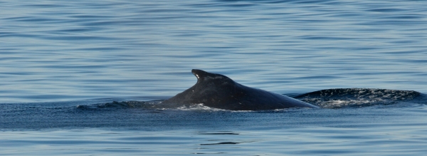 As we were turning towards the orcas, a 30′ minke whale cruised right by our boat – wildlife overload! We were able to drift and watch the orcas for about 45 minutes.The population of the Broughtons numbered several thousand people around the turn of the 20th century, but is now much smaller. Logging and fishing are still the primary activities, with tiny little “settlements” – groups of floathouses in a sheltered bay, or tiny little marinas all on log floats. The little marinas are very social, with nightly appy hours or pot luck dinners and a chance to meet other cruisers. As we were turning towards the orcas, a 30′ minke whale cruised right by our boat – wildlife overload! We were able to drift and watch the orcas for about 45 minutes.The population of the Broughtons numbered several thousand people around the turn of the 20th century, but is now much smaller. Logging and fishing are still the primary activities, with tiny little “settlements” – groups of floathouses in a sheltered bay, or tiny little marinas all on log floats. The little marinas are very social, with nightly appy hours or pot luck dinners and a chance to meet other cruisers.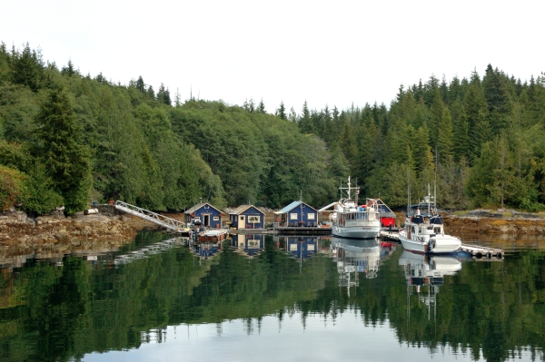 Sometimes there are logging roads or trails to hike, but we’re always watchful for bears. We carry bear bells, bear spray, and an air horn when we hike… just in case. Mostly the bears don’t like people, so if they hear people noises they will avoid you. We’ve seen bear scat – pretty fresh, and tracks in the mud at low tide (where they come to dig for clams and turn over rocks looking for crabs)… but we haven’t seen any yet. It’s sort of a good news/bad news thing. Sometimes there are logging roads or trails to hike, but we’re always watchful for bears. We carry bear bells, bear spray, and an air horn when we hike… just in case. Mostly the bears don’t like people, so if they hear people noises they will avoid you. We’ve seen bear scat – pretty fresh, and tracks in the mud at low tide (where they come to dig for clams and turn over rocks looking for crabs)… but we haven’t seen any yet. It’s sort of a good news/bad news thing.The anchorages are very quiet and pretty, with maybe one or two other boats in the busy summer season. We’ve seen bald eagles, kingfishers, ravens, mergansers, red-throated loons, murres, murrelets, and one of my new favorite birds – the rhinocerous auklet. 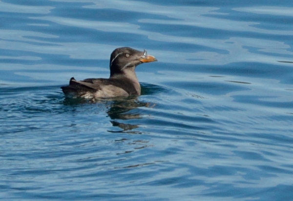 They are a very small, chubby seabird, with this wonderful “horn” at the base of their beak.The views are just stunning, the wildlife is abundant, the big salmon are jumping… it’s a very special area that we’re just beginning to explore. I’ve put a lot of miles on my kayak, enjoying the huge difference between low tide and high tide – about 14′ around here. The landscape is very different at either end of the tide cycle. Stay tuned for more… They are a very small, chubby seabird, with this wonderful “horn” at the base of their beak.The views are just stunning, the wildlife is abundant, the big salmon are jumping… it’s a very special area that we’re just beginning to explore. I’ve put a lot of miles on my kayak, enjoying the huge difference between low tide and high tide – about 14′ around here. The landscape is very different at either end of the tide cycle. Stay tuned for more… |


Broughton Stories – August 27, 2013 |
We found many quiet anchorages to explore, mostly by kayak. Paddling has been the best way to see a lot of wildlife and get into rocky nooks and crannies. Seals peek at us from a safe distance, and one day I saw one watching me. Next to the seal was a little nose sticking out of the water.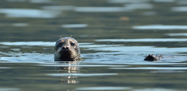 I slowly meandered closer and closer, and finally came up next to the little nose – it was a baby seal, fast asleep. I floated there very quietly and he started to move a little… finally opening his eyes and giving me a sleeply look. Then he woke up all the way, looked at me with surprised wide eyes, and swam off. The same day I watched a bald eagle attack something right on the surface of the water. He actually landed in the water and struggled with it, using his wings to “swim” with it to the nearest island where I lost sight of him. I slowly meandered closer and closer, and finally came up next to the little nose – it was a baby seal, fast asleep. I floated there very quietly and he started to move a little… finally opening his eyes and giving me a sleeply look. Then he woke up all the way, looked at me with surprised wide eyes, and swam off. The same day I watched a bald eagle attack something right on the surface of the water. He actually landed in the water and struggled with it, using his wings to “swim” with it to the nearest island where I lost sight of him. 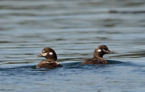 Paddling around another little island I came upon these two young white winged scoters……and around the next island I woke a pair of seals napping on a rock (they’re very well camouflaged). Paddling around another little island I came upon these two young white winged scoters……and around the next island I woke a pair of seals napping on a rock (they’re very well camouflaged).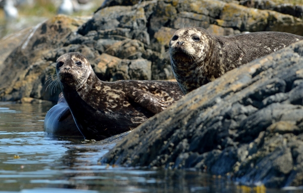 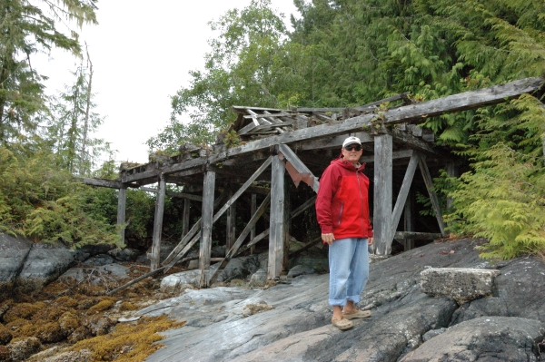 We did some exploring by dinghy one day since we wanted to see some ruins of an old sawmill. There wasn’t much left except some wood beams, but it was interesting to see. In another cove we found two flocks of mergansers, and then we went to see the “waterfall” from a lagoon that sits higher than the main waterway, so it floods at high tide and drains partially at low tide, creating a little waterfall. We took a picnic lunch in the dinghy with us, planning to check out some other anchorages nearby but light rain showers turned into a real downpour… and of course we were miles from the boat. An adventure! We did some exploring by dinghy one day since we wanted to see some ruins of an old sawmill. There wasn’t much left except some wood beams, but it was interesting to see. In another cove we found two flocks of mergansers, and then we went to see the “waterfall” from a lagoon that sits higher than the main waterway, so it floods at high tide and drains partially at low tide, creating a little waterfall. We took a picnic lunch in the dinghy with us, planning to check out some other anchorages nearby but light rain showers turned into a real downpour… and of course we were miles from the boat. An adventure!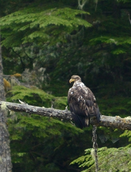 We had the anchorage in the back of Joe Cove all to ourselves, and we watched a young bald eagle hunting every day. He doesn’t develop the white head and tail until he’s about 3 years old. We had the anchorage in the back of Joe Cove all to ourselves, and we watched a young bald eagle hunting every day. He doesn’t develop the white head and tail until he’s about 3 years old.
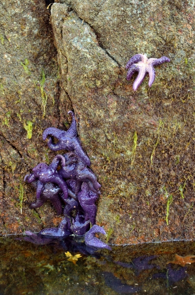
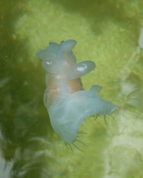
The kayaking was great despite some gloomy weather, and at low tide we found basket stars, sea squirts, moon jellyfish, and even a sea angel (hooded nudibranch) – a strange, gelatinous creature about 5 inches long with little wings and cilia around its mouth.
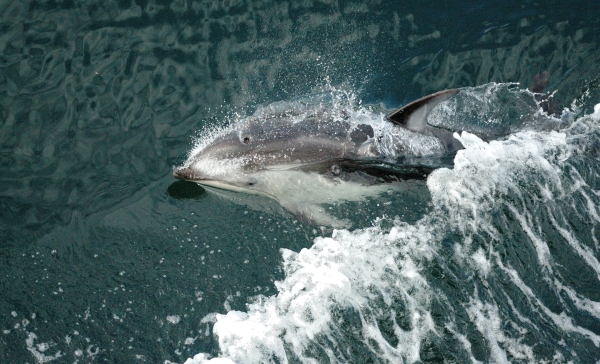
In one place people reported seeing about 300 dolphin churning the bay hunting, and a bear was swimming after the fish, among the dolphins – wow. |
Broughton Post Cards – September 13, 2013 |
||
| I have a few more photos of things we saw in the Broughtons, so I’ll just share them as “post cards”. These are dedicated to our several friends who are struggling with health problems – nature’s best pales in comparison to the beauty of friendship.
|
Johnstone Strait Back to the Gulf Islands – October 4, 2013 |
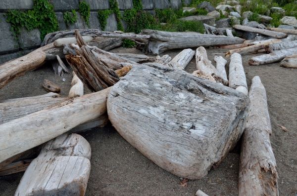
I apologize for letting the blog get so far behind reality. Right now we’re actually in US waters, in Port Townsend taking a little cruising pause. I’ll try to catch things up in the next few entries.We were sad to leave the Broughtons – it was our favorite cruising area this summer since it was the most wild and quiet and full of wildlife. There are two major paths to head south – through the several rapids along the “back way” (the path we took northbound), or through the wider Johnstone Strait and Seymour Narrows, where the big ships go. We decided to try the Johnstone route, though we still had to time our passage through Seymour Narrows very carefully. We watched a 110′ commercial fishing boat transit the narrows 2 hours before slack current and we could see him fishtailing in the strong turbulence. We slowed down and made an uneventful passage 75 minutes later, and tucked into the town of Campbell River for a few days.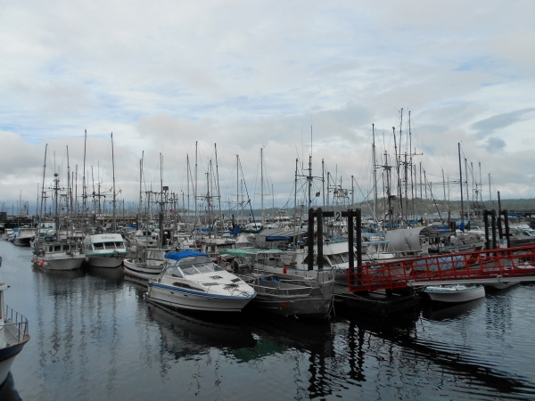 Jim needed to see a dentist to patch his cracked tooth, and we wanted to check out the town. Despite a lot of rain, we had a great time exploring, particularly the museum and maritime center.We continued down Discovery Passage to the town of Comox, and we were glad to finally escape the strong winds that made the trip somewhat uncomfortable. Comox was another lovely town and we met a great couple on a 1972 wood Alaskan – a very close cousin to our type of boat. You have to love a town that makes condo balconies out of boats! Jim needed to see a dentist to patch his cracked tooth, and we wanted to check out the town. Despite a lot of rain, we had a great time exploring, particularly the museum and maritime center.We continued down Discovery Passage to the town of Comox, and we were glad to finally escape the strong winds that made the trip somewhat uncomfortable. Comox was another lovely town and we met a great couple on a 1972 wood Alaskan – a very close cousin to our type of boat. You have to love a town that makes condo balconies out of boats! 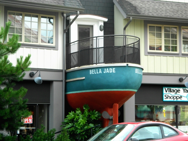 We continued southwards, spotting another male orca just north of Nanaimo, and stopping in Montague Harbor in the Gulf Islands. We continued southwards, spotting another male orca just north of Nanaimo, and stopping in Montague Harbor in the Gulf Islands.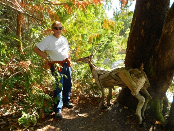 We were hiking through the woods and found this wonderful driftwood sculpture – someone is very talented!We were able to link up with our good friends Linda and Ed, and we had a very happy reunion with them. They headed off to fish and crab for a few days, but we were able to rendezvous again for one last hurrah at Sidney Spit in the Gulf Islands. We were hiking through the woods and found this wonderful driftwood sculpture – someone is very talented!We were able to link up with our good friends Linda and Ed, and we had a very happy reunion with them. They headed off to fish and crab for a few days, but we were able to rendezvous again for one last hurrah at Sidney Spit in the Gulf Islands.
Sidney Spit is a neat little island just a few miles from the town of Sidney, with great birding and some nice hiking trails in the woods.
|
Back to the US of A! – October 16, 2013 |
We last left you when we were in Sidney Spit getting ready to cross from Canada back into the US – a whopping 6 miles! Fortunately we now have NEXUS cards – a Trusted Traveler system that makes going between the US and Canada much easier. We might still be stopped for a Customs inspection, but it’s much less likely and most of the time we can clear in with a phone call. Luckily, the phone call is all we needed and we could proceed directly to our chosen anchorage instead of heading to the Customs dock.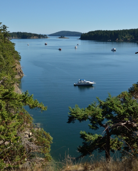 We decided to check out Reid Harbor on Stuart Island in the northern San Juan Islands for a little hiking. It’s a pretty, long anchorage with some mooring balls and a dock provided by the Washington State Park system. We decided to check out Reid Harbor on Stuart Island in the northern San Juan Islands for a little hiking. It’s a pretty, long anchorage with some mooring balls and a dock provided by the Washington State Park system.
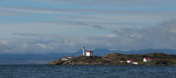
We continued on to the see the light house at Turn Point – the northernmost point on the island, and the place along the US-Canada border where big ships make a fairly hard turn to head up the Strait of Georgia or down and out the Strait of Juan de Fuca to the Pacific Ocean. It’s a pretty spot and the old lighthouse and buildings are very well cared for. We looked for orcas – they are often spotted here in the strong current, but we didn’t see any this time.
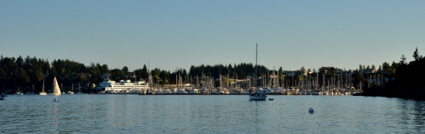
We were running low on some fresh things like milk and veggies so we decided to explore the town of Friday Harbor next. It’s a pretty big town on San Juan Island, and we anchored nearby so we could watch all the comings and goings of this busy place. |
A Maintenance Pause in Port Townsend – October 18, 2013 |
After we left Friday Harbor the weather was not the best to really enjoy the San Juans, and Jim’s broken tooth really needed some attention. We found a dentist in Bellingham, WA and headed there with the boat. We’re not used to the typical Washington marinas that are run by the towns – they don’t take reservations, the staff isn’t very helpful, and they have very little/no 50Amp power – which we really like to have so we can run our washer/dryer and electric heating systems. But the important thing was the dentist, and it turned out that Jim only needs a crown and not an implant – whew!In addition to the dentist, our boat is now 25 years old and our insurance company requires us to have a professional survey done – out of the water. DeFever friends Jim and Susan recommended their favorite boat yard in Port Townsend, WA, so that was our next stop. Actually we made the arrangements for the haul-out and survey two months ago, just to make sure everything would be done in time for the insurance renewal. Port Townsend is a great town, with old Victorian homes and buildings, great little shops and cafes (which we barely had time to visit), a Maritime Center, and lots of activities and classes at the decommissioned Fort Worden nearby.We didn’t realize that this yard offers services for “regular” boats as well as the behemoths – large commercial fishing boats, float houses, and huge yachts. When we were in the water our slip had a perfect view of all the activity around the 300 ton travel lift. Port Townsend is a great town, with old Victorian homes and buildings, great little shops and cafes (which we barely had time to visit), a Maritime Center, and lots of activities and classes at the decommissioned Fort Worden nearby.We didn’t realize that this yard offers services for “regular” boats as well as the behemoths – large commercial fishing boats, float houses, and huge yachts. When we were in the water our slip had a perfect view of all the activity around the 300 ton travel lift. 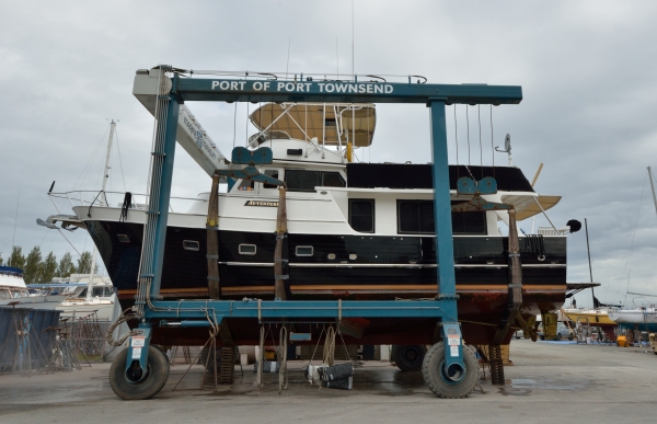 Our boat weighs 32 tons and we were hauled by an 80 ton lift seen here (with the operator and his wireless control in the lower left)… Our boat weighs 32 tons and we were hauled by an 80 ton lift seen here (with the operator and his wireless control in the lower left)…
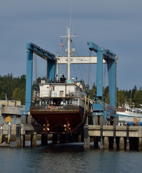 300 Ton Lift And compare that to the massive 300 ton lift that can pick up a big steel commercial fishing boat like the kind you see on Deadliest Catch…The tires on the big lift are almost 8 feet tall, just to give you some perspective. The yard was full of old boats, new boats, work boats, pleasure boats, steel, wood, fiberglass… and lots of real craftsmen and women who can do any kind of repair you might need. What a cool place!
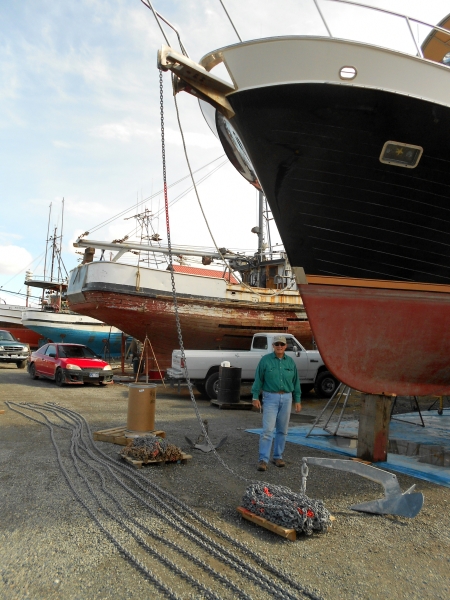
Getting hauled out is never fun – it means long hours and lots of boat yard dirt, and climbing a tall ladder to get on and off the boat. And we always hope the travel lift operator blocks our boat level so things stay “normal” inside since we stay aboard. But we got a lot accomplished, and took the opportunity to replace our main anchor chain, among many other little jobs. |
New Places Around Puget Sound – November 3, 2013 |
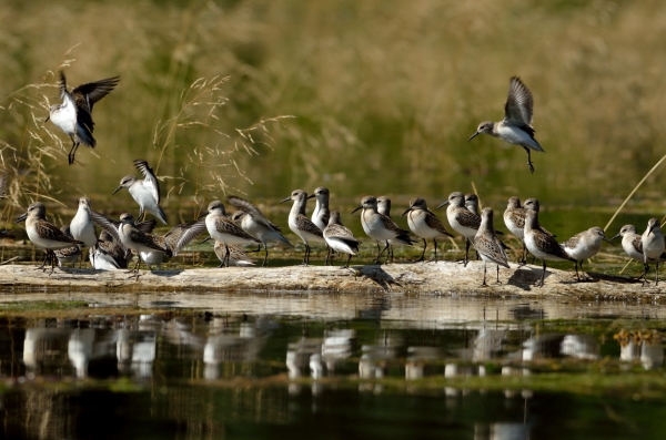
| We had a good pause in Port Townsend, taking care of a lot of little maintenance chores and small repairs, but it was more work than fun. We had a wonderful visit from our friends Bonnie & Walt, and we got to see a little of the town. We also rented a car to get Jim to the dentist for his crown prep, and we had a big shopping day to re-stock the freezer and to get some new jeans and socks and flannel sheets. Some of our friends put their boats away for the winter so they could head to warmer places, and we were sad to see them go. It’s hard to watch friends leave or to hear about our east coast friends migrating south for the winter… not us this year. Our only consolation is that the winters out here are milder than the winters when we lived aboard in Annapolis. And we’ll be able to head to Alaska in April for a nice long summer season. We’re still glad we moved out here, though we occasionally get a pang of regret on chilly, dreary days. But then we remember the orcas and eagles and whales, and we’re glad we did it.  We made our escape to explore the town of Poulsbo, WA and to join a local MTOA weekend rendezvous there. The trees were in full fall color, and the town was just great – friendly, with nice shops (including a yarn shop and a bead store), great restaurants, and a famous bakery (which made Jim very happy). We made our escape to explore the town of Poulsbo, WA and to join a local MTOA weekend rendezvous there. The trees were in full fall color, and the town was just great – friendly, with nice shops (including a yarn shop and a bead store), great restaurants, and a famous bakery (which made Jim very happy).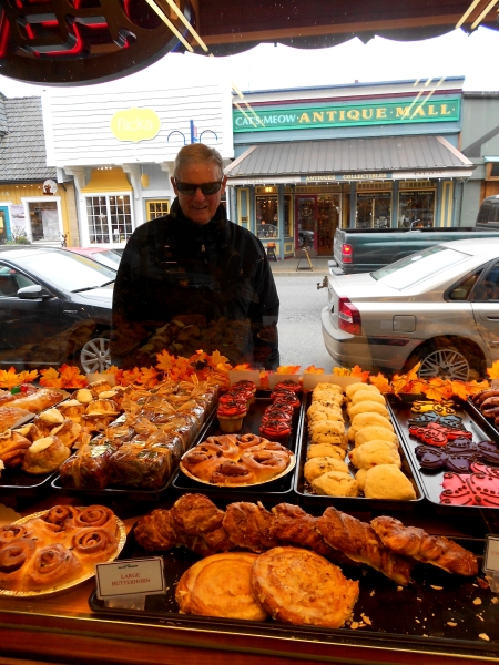 We met a lot of nice people at the MTOA rendezvous, and the dockmaster organized a scavenger hunt for us throughout the town, ending at a micro-brewery. We all had a ball, and it was great to be out and about in the crisp fall weather. We got a lot of suggestions for more places to go here in Puget Sound, and an invitation to visit Cathryn and Bob in Gig Harbor. We met a lot of nice people at the MTOA rendezvous, and the dockmaster organized a scavenger hunt for us throughout the town, ending at a micro-brewery. We all had a ball, and it was great to be out and about in the crisp fall weather. We got a lot of suggestions for more places to go here in Puget Sound, and an invitation to visit Cathryn and Bob in Gig Harbor.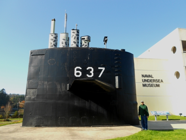 We hated to leave Poulsbo – it was just so nice, but we wanted to check out the Naval Undersea Museum in nearby Keyport. Keyport has a tiny town dock with cheap dockage and free electric, though it doesn’t have much else. We absolutely loved the Navy’s museum, spending 4 hours until closing time – we could have stayed longer. No one had a a dry eye reading about the heroics of some of the submarine commanders and crews. We found out that our friend Ted, a retired Navy EOD officer, went to diving school in Keyport in 1962, and was responsible for the placement of a mine from the first Gulf War into the museum’s exhibits – very cool! We hated to leave Poulsbo – it was just so nice, but we wanted to check out the Naval Undersea Museum in nearby Keyport. Keyport has a tiny town dock with cheap dockage and free electric, though it doesn’t have much else. We absolutely loved the Navy’s museum, spending 4 hours until closing time – we could have stayed longer. No one had a a dry eye reading about the heroics of some of the submarine commanders and crews. We found out that our friend Ted, a retired Navy EOD officer, went to diving school in Keyport in 1962, and was responsible for the placement of a mine from the first Gulf War into the museum’s exhibits – very cool!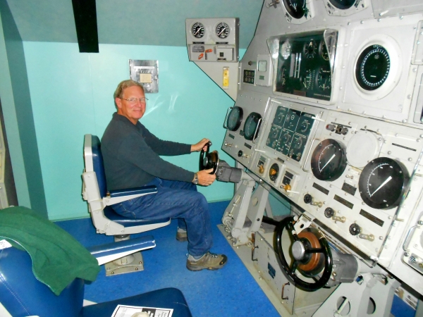 Along the way, we saw some nice ducks – Barrows goldeneye, surf scoters, and these oldsquaw. Along the way, we saw some nice ducks – Barrows goldeneye, surf scoters, and these oldsquaw. 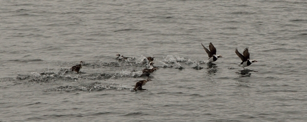 (I love my birds.)The temperature has dropped and the fall pattern seems to be well established. It’s often foggy and overcast in the mornings, but it can turn sunny, bright, and warm in the afternoons… or not. We never know, so we’ve learned to dress in layers. It’s actually nice to be cruising in the off season, since it’s quiet on the waterway except for the big ferries that are always running around. (I love my birds.)The temperature has dropped and the fall pattern seems to be well established. It’s often foggy and overcast in the mornings, but it can turn sunny, bright, and warm in the afternoons… or not. We never know, so we’ve learned to dress in layers. It’s actually nice to be cruising in the off season, since it’s quiet on the waterway except for the big ferries that are always running around. |
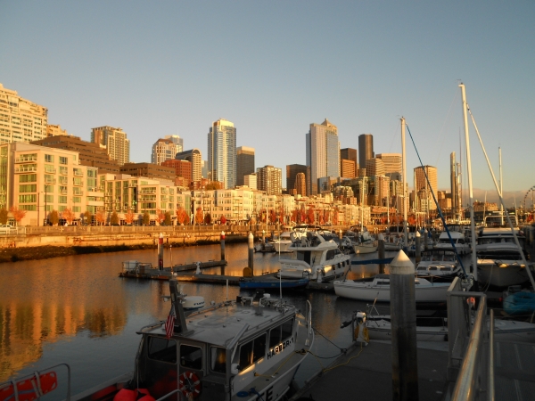
Blake Island and Seattle – November 11, 2013 |
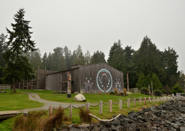 Just a short 7 miles from Seattle is Blake Island State Park – a great place to stop for some hiking and walking. It’s about 5 miles in circumference, heavily wooded, with some mooring balls and a breakwater and docks. There’s also an Indian Big House that is home to a cultural show and lunch or dinner for tourists who are brought out by boat from Seattle. Just a short 7 miles from Seattle is Blake Island State Park – a great place to stop for some hiking and walking. It’s about 5 miles in circumference, heavily wooded, with some mooring balls and a breakwater and docks. There’s also an Indian Big House that is home to a cultural show and lunch or dinner for tourists who are brought out by boat from Seattle.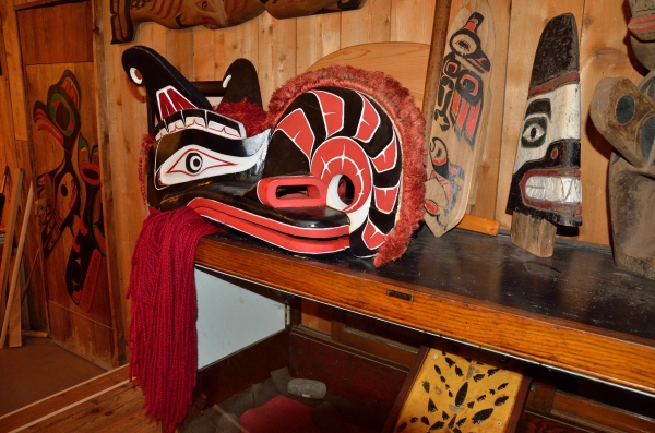 Mid-week in the fall is a nice time to enjoy the park, and the black-tailed deer population seemed to enjoy the quiet. (We did too!) Mid-week in the fall is a nice time to enjoy the park, and the black-tailed deer population seemed to enjoy the quiet. (We did too!)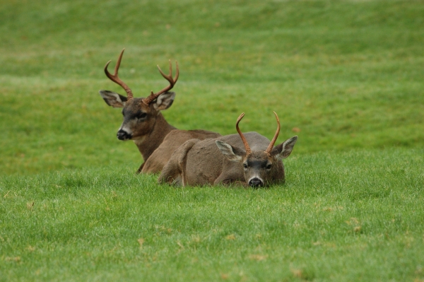
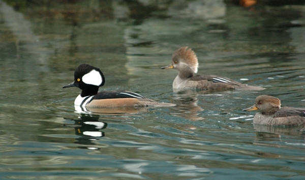 Hooded Mergansers Bird watching continues to be very good, with some surf scoters, loons, and hooded mergansers keeping us company.
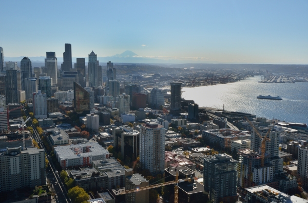
We had a few days of beautiful weather and clear skies, and we wanted to take advantage of the views so we went up the Space Needle and got the big picture: the mountains and the city and the water – something for everyone! (Mt. Rainier is in the far distance.)
It was certainly interesting being in a city on Halloween. People watching is always fun, but on Halloween it was genuinely hard to tell if some people were wearing a costume, or if they normally dressed that way. We saw a lot of that! I think living on the water must keep us a bit “sheltered”. |


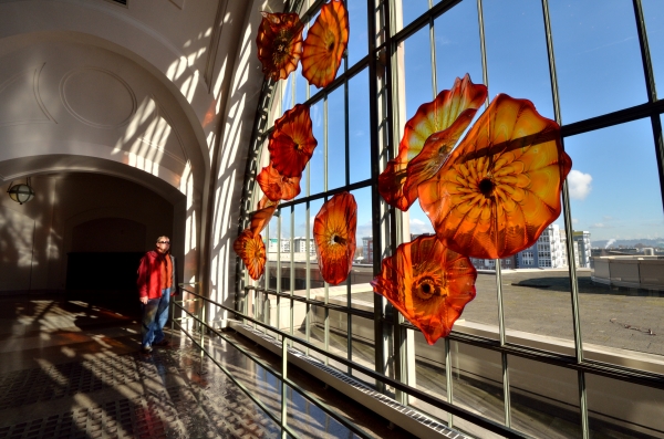
Tacoma and Art Glass – November 15, 2013 |
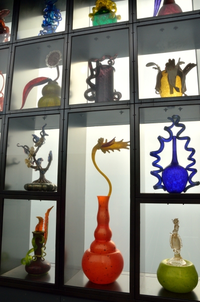
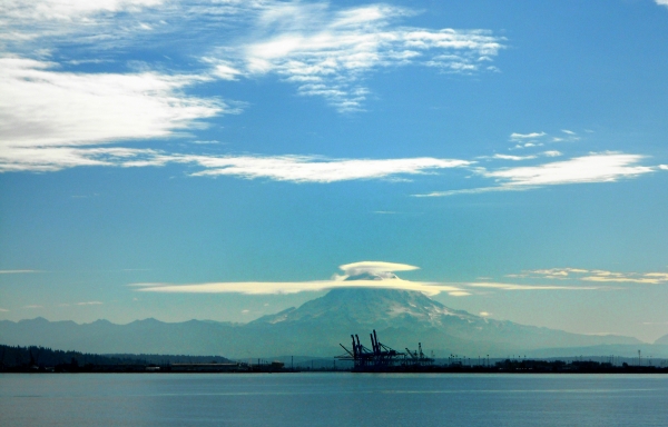 We were always excited when we had a high enough vantage point (and clear skies) in Seattle to get a glimpse of Mt. Rainier. Heading south to Tacoma we cruised around the point and got a fantastic view of the mountain, with the cranes of Tacoma’s working waterfront in the foreground. Notice the lens-shaped cloud sitting on the mountain top – it’s a lenticular cloud, and is common around the tall mountains here.Friends recommended the marina in front of the Museum of Glass in downtown Tacoma, near the Bridge of Glass leading to the Art Museum and Washington State History Museum, as well as some shops and good restaurants – very convenient! Tacoma wasn’t as impressive as Seattle overall, but since it’s the home of the famous glass artist Dale Chihuly, it seems to be the center of the universe for art glass. We were always excited when we had a high enough vantage point (and clear skies) in Seattle to get a glimpse of Mt. Rainier. Heading south to Tacoma we cruised around the point and got a fantastic view of the mountain, with the cranes of Tacoma’s working waterfront in the foreground. Notice the lens-shaped cloud sitting on the mountain top – it’s a lenticular cloud, and is common around the tall mountains here.Friends recommended the marina in front of the Museum of Glass in downtown Tacoma, near the Bridge of Glass leading to the Art Museum and Washington State History Museum, as well as some shops and good restaurants – very convenient! Tacoma wasn’t as impressive as Seattle overall, but since it’s the home of the famous glass artist Dale Chihuly, it seems to be the center of the universe for art glass. 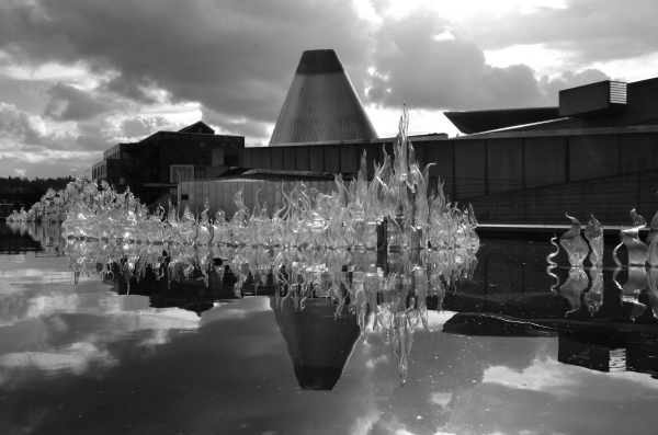 The Museum of Glass is an interesting building, with a huge cone where the glass furnaces and “hot shop” are located and a glass sculpture in the reflecting pool out front. The Museum of Glass is an interesting building, with a huge cone where the glass furnaces and “hot shop” are located and a glass sculpture in the reflecting pool out front.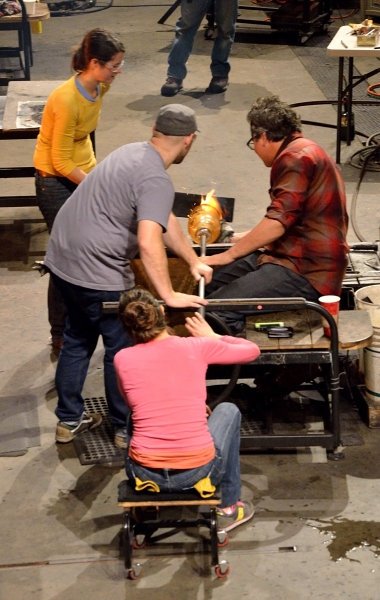 The weekend we were there, the museum was hosting a special Chihuly project in the hot shop – we had to check that out. Chihuly himself doesn’t work with glass anymore; he has a team of craftspeople and artists who do all the work, inspired by Dale’s paintings and ideas. Just watching the artists working with the molten glass was so interesting – art with an element of danger! There are many chances for ugly things to happen with so many people working in concert. The weekend we were there, the museum was hosting a special Chihuly project in the hot shop – we had to check that out. Chihuly himself doesn’t work with glass anymore; he has a team of craftspeople and artists who do all the work, inspired by Dale’s paintings and ideas. Just watching the artists working with the molten glass was so interesting – art with an element of danger! There are many chances for ugly things to happen with so many people working in concert.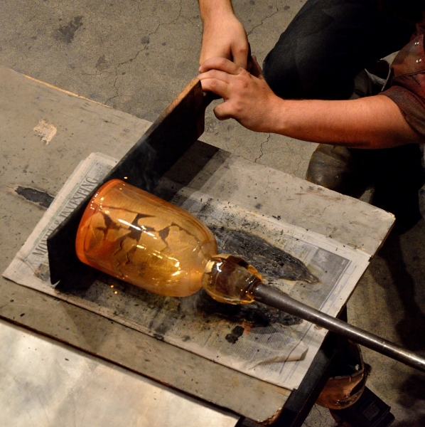
The rest of the Museum of Glass was fabulous – the variety of techniques and styles, colors and shapes from so many different artists – it boggles the mind. It was our favorite museum of all that we’ve seen.
|


Gig Harbor, Port Townsend, and Bellingham – November 24, 2013 |
From Tacoma we cruised a short distance to the little fishing town of Gig Harbor to visit new friends Cathryn and Bob. They treated us to a nice home-cooked dinner in their gorgeous home, right on Colvos Passage. We had a great time and a lot of laughs, especially when we discovered that we knew some of the same boaters on the east coast! It is a VERY small world on the water. We had a grand time with our new friends, and we loved walking around the town of Gig Harbor – great shops, restaurants, scenery, and a nice little museum.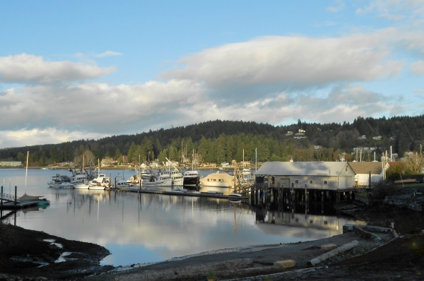 With another dentist appointment and a date to meet a fuel truck looming, it was time to head back to the north end of Puget Sound. As we cruised out of Gig Harbor and up Colvos Passage, Bob and Cathryn came out on their deck to wave to us (nice jammies). With another dentist appointment and a date to meet a fuel truck looming, it was time to head back to the north end of Puget Sound. As we cruised out of Gig Harbor and up Colvos Passage, Bob and Cathryn came out on their deck to wave to us (nice jammies). We cruised north to Port Townsend, getting a slip at the “downtown” end of town to play tourist. These small towns have some really lovely shops, and most of them seem to have very creative and beautiful window displays. The whole region is very artsy, and it manifests itself in many different ways. We cruised north to Port Townsend, getting a slip at the “downtown” end of town to play tourist. These small towns have some really lovely shops, and most of them seem to have very creative and beautiful window displays. The whole region is very artsy, and it manifests itself in many different ways.We saw a number of river otters playing in the marina (and leaving a lot of fishy, smelly messes on the docks), but they were never around when I had a camera handy! We were careful to keep our side gate closed to make sure they didn’t come aboard for a visit. We did see a lot of hooded mergansers – the “hood” on the male is most impressive when he’s surprised or alert. We were supposed to cruise across to Bellingham on Tuesday to get Jim to the dentist on Wednesday. The weather forecast looked fine for the crossing, but we woke up on Tuesday morning at 5 AM to howling winds – time for Plan B! Without any discussion, I pulled up the ferry schedule and Jim called the local car rental place. That’s life as a cruiser – you have to stay flexible. It’s an all-day event with the ferry crossing and a long drive each way, but we made it a fun day. One of the rewards for getting “stuck” in Port Townsend a bit longer was watching a nuclear submarine heading out to sea. We were in the pilothouse and just happened to look up and see her – wow! 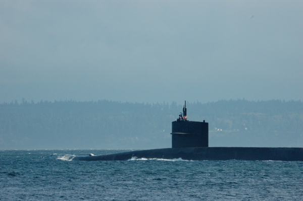 We had fun poking around town until the weather improved enough for us to get over to Bellingham. We met a fuel truck on the commercial dock and filled our tanks at a decent price – we hope that’s enough fuel to last us until we get to Ketchikan, Alaska in the spring since fuel is very expensive in Canada. We took advantage of some rainy days to do a few chores, and now we’re heading into the San Juan Islands for the next 10 days. We had fun poking around town until the weather improved enough for us to get over to Bellingham. We met a fuel truck on the commercial dock and filled our tanks at a decent price – we hope that’s enough fuel to last us until we get to Ketchikan, Alaska in the spring since fuel is very expensive in Canada. We took advantage of some rainy days to do a few chores, and now we’re heading into the San Juan Islands for the next 10 days. |
25 Years – November 26, 2013 |
Today is our 25th Wedding Anniversary – where has the time gone?  This week also marks 9 years since we moved aboard the boat full-time. Living in a small space has its own challenges, but we still love it. It has been a pretty fabulous journey together so far, and we hope and pray that we get to keep having Adventures together for a long time to come.We have a picture in the boat with a quote from Antoine de Saint-Exupery that really says it all:”Love does not consist in gazing at each other, but in looking outward together in the same direction.” This week also marks 9 years since we moved aboard the boat full-time. Living in a small space has its own challenges, but we still love it. It has been a pretty fabulous journey together so far, and we hope and pray that we get to keep having Adventures together for a long time to come.We have a picture in the boat with a quote from Antoine de Saint-Exupery that really says it all:”Love does not consist in gazing at each other, but in looking outward together in the same direction.”
Thanks a million, Sweetie, for so much happiness and for making my dreams come true. |
San Juan Islands – November 27, 2013 |
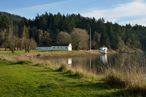
It’s a short hop from Bellingham into the San Juan Islands, which is a good thing since we had some strong northerly wind and choppy conditions to deal with. We anchored off Lopez Island to hide from the wind, and had the anchorage all to ourselves (where is everybody – it’s not that cold, is it?). 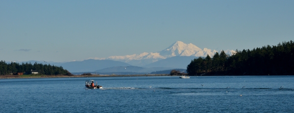 We had a great view of Mt. Baker in the Cascade Mountain range to the east……and we particularly enjoyed its many faces as the light changed. Dawn was my favorite look. We had a great view of Mt. Baker in the Cascade Mountain range to the east……and we particularly enjoyed its many faces as the light changed. Dawn was my favorite look.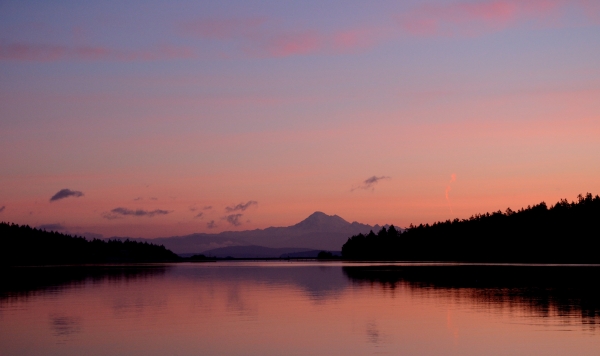 The winds settled down and we were due to get a cold snap. We had to hose the foredeck off with salt water to get rid of the thick layer of frost, and we got a laugh at the bird footprints in the frost on one of the deck boxes. It’s no fun to run around in the dinghy in the cold, so we decided to head to the marina at Friday Harbor for the two coldest nights. It was nice – we went to the movies, visited the knitting shop (where I found yarn and a vest pattern that I couldn’t resist), and walked around town. After two days, as it was starting to warm back up to normal temps (daytime in the mid-high 40’s) we ran around to the NW side of San Juan Island to visit the National Park site called English Camp. The winds settled down and we were due to get a cold snap. We had to hose the foredeck off with salt water to get rid of the thick layer of frost, and we got a laugh at the bird footprints in the frost on one of the deck boxes. It’s no fun to run around in the dinghy in the cold, so we decided to head to the marina at Friday Harbor for the two coldest nights. It was nice – we went to the movies, visited the knitting shop (where I found yarn and a vest pattern that I couldn’t resist), and walked around town. After two days, as it was starting to warm back up to normal temps (daytime in the mid-high 40’s) we ran around to the NW side of San Juan Island to visit the National Park site called English Camp.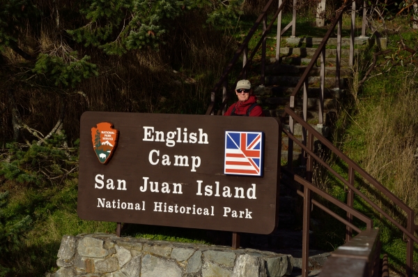
This is where the English military established a camp for the 12 years when the ownership of the San Juan Islands was in dispute. The Americans had a camp on the south end of the island, and the two sides enjoyed each other’s company during the political dispute known as the Pig War. (The only fatality was a pig.) We hiked up the mountain above English Camp, and had some fantastic views of the Olympic Mountains, the Gulf Islands, and Vancouver Island. If you look closely, ADVENTURES is the little dark speck at anchor just to the lower left of center in this photo. |
Thanksgiving at Rosario Resort – November 30, 2013 |
Our friends Bonnie and Walt recommended Rosario Resort on Orcas Island, and we thought it would be a great place to celebrate our anniversary and Thanksgiving – something a little special (though it’s hard to imagine anything more special than the cruising season we’ve been having out here!)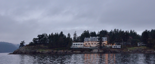 The photo isn’t the greatest shot of the mansion – I took it early on an overcast morning. It’s a lovely spot and the late 1800’s mansion has been beautifully restored.The place had just that kind of special feeling we needed – especially since we were really missing our friends and family for the Thanksgiving holiday. We took solace in some of the amenities at Rosario – the hot tub and some spa treatments. We explored the property and admired the grand view looking down Eastsound Bay to the south. The photo isn’t the greatest shot of the mansion – I took it early on an overcast morning. It’s a lovely spot and the late 1800’s mansion has been beautifully restored.The place had just that kind of special feeling we needed – especially since we were really missing our friends and family for the Thanksgiving holiday. We took solace in some of the amenities at Rosario – the hot tub and some spa treatments. We explored the property and admired the grand view looking down Eastsound Bay to the south.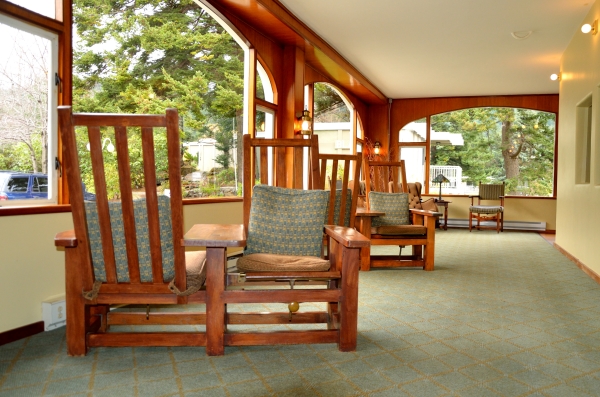 We liked sitting by the marble chip fireplace, and we had scones and hot tea one morning, sitting in this nifty side-by-side chair (a single piece of furniture). We liked sitting by the marble chip fireplace, and we had scones and hot tea one morning, sitting in this nifty side-by-side chair (a single piece of furniture).
Growing up in NJ, I always went to my godparent’s place for the big family Thanksgiving dinner, which was wonderful. We never thought anything about it, but my godparents lived in a large apartment above the funeral home that they owned and operated. When my brother and I were at that age where we were easily bored, Dad would take us downstairs and play hide-and-seek. We never bothered with any rooms where someone was laid out, but we liked the smell of fresh flowers there. In later years we enjoyed talking with the “holiday strays” at dinner – friends or people who didn’t have anywhere to go for the holiday. Sometimes they were people who worked at the funeral home… free-lance embalmers, hair dressers, etc. Ask me sometime about the car my parents borrowed to take me to college. You really can’t make this stuff up. We were planning to do some serious hiking Friday and Saturday, and then enjoy the music and history presentation, but the weather report predicted some very strong fronts. The only prudent choice was to leave the day after Thanksgiving and head to Victoria, BC – where we’ll spend the winter. We were sad to leave Rosario, but we’ll be back! |
Victoria and the Holiday Season – December 12, 2013 |
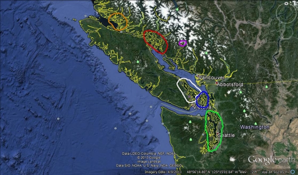
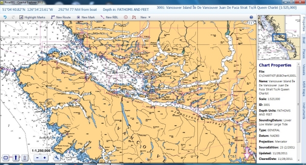
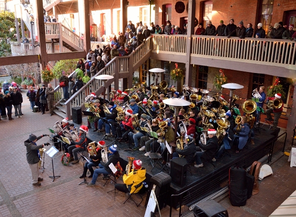
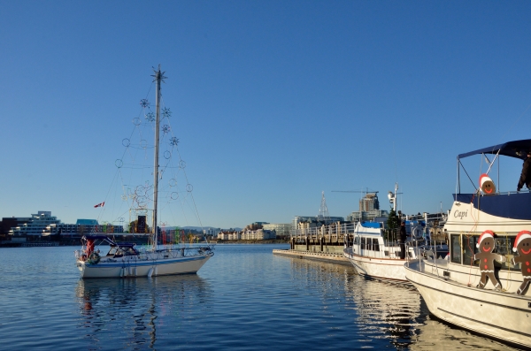
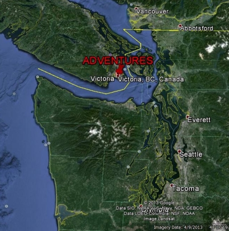 Where are we? We’re now settled for the winter in Victoria, BC on the south end of Vancouver Island. You might notice that Vancouver is at the top of the map, on the mainland… not on Vancouver Island. The yellow line is the US-Canada border, and the group of islands under the “RES” of our boat name are the San Juans. We traveled as far south as Tacoma, and much farther north than this map shows in this first season of cruising the Pacific NW. Where are we? We’re now settled for the winter in Victoria, BC on the south end of Vancouver Island. You might notice that Vancouver is at the top of the map, on the mainland… not on Vancouver Island. The yellow line is the US-Canada border, and the group of islands under the “RES” of our boat name are the San Juans. We traveled as far south as Tacoma, and much farther north than this map shows in this first season of cruising the Pacific NW.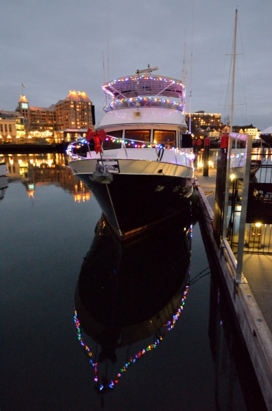 Here we are at the dock – decorated for Christmas – we even won a prize from the Harbour Authority for our decorations!Victoria is a lovely small city, and it really goes all out for the holidays. The first big event for us was to go see Tuba Christmas – a 40 year old tradition where musicians of all ages come together to perform. It’s a very special memory for us since we always went with our friends the Halls to hear Ed play. We even trooped up to NYC one year to hear him play on the ice at Rockefeller Center! We loved hearing all the music and getting into the holiday spirit, despite the fact that this year Victoria was in the midst of an unusual cold snap – the temp was 20 degrees. Here we are at the dock – decorated for Christmas – we even won a prize from the Harbour Authority for our decorations!Victoria is a lovely small city, and it really goes all out for the holidays. The first big event for us was to go see Tuba Christmas – a 40 year old tradition where musicians of all ages come together to perform. It’s a very special memory for us since we always went with our friends the Halls to hear Ed play. We even trooped up to NYC one year to hear him play on the ice at Rockefeller Center! We loved hearing all the music and getting into the holiday spirit, despite the fact that this year Victoria was in the midst of an unusual cold snap – the temp was 20 degrees.
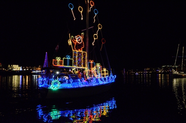
With frozen toes but a bounce in our step we headed home to watch the boats gather for the evening’s lighted boat parade.
The sailboat approaching the dock turned out to be the star of the parade. He had an animated Santa that popped out of a package, with balloons that floated up.
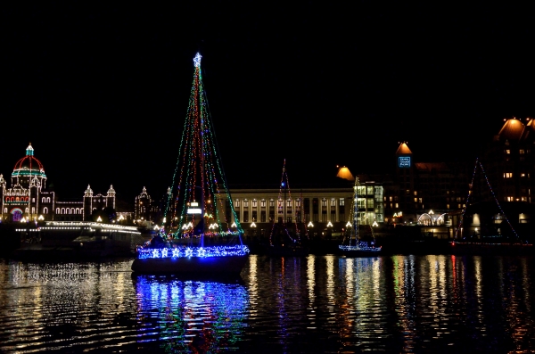
There is a lot more to photograph around town – all the pretty lights and decorated store windows. Now that it’s warmer, it’s much more appealing to go out with my camera after dark.It has been pretty quiet around our dock, and we were hoping to meet more liveaboard neighbors… but there don’t seem to be many, and people aren’t outside as much in the colder weather. We’re working on finding people and community that we can connect with for the winter months, and I’m sure we will. |
Christmas at Victoria’s Butchart Gardens – December 20, 2013 |
Christmas in Victoria wouldn’t be complete without a visit to the famous Butchart Gardens. We visited the gardens by boat in early summer, and were astounded at the size and variety: an Italian formal garden, a Japanese garden, an amazing rose garden, and the huge sunken garden. There are things to see in every season, even in winter when little touches like a small owl totem are easier to notice. Locals recommended that we get an annual pass so we could visit the gardens as often as we liked, especially around Christmas.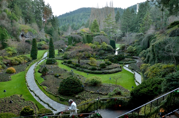 We had heard about all the lights, but we wanted to see the gardens before it got dark.The sunken garden is a favorite area, with a meandering path, cliff sides, a pond, and a small waterfall all surrounded by tall evergreen trees. In winter during daylight hours it’s pretty, but without the explosion of color that you would see in the other seasons. And here is the view of the sunken garden at night… We had heard about all the lights, but we wanted to see the gardens before it got dark.The sunken garden is a favorite area, with a meandering path, cliff sides, a pond, and a small waterfall all surrounded by tall evergreen trees. In winter during daylight hours it’s pretty, but without the explosion of color that you would see in the other seasons. And here is the view of the sunken garden at night…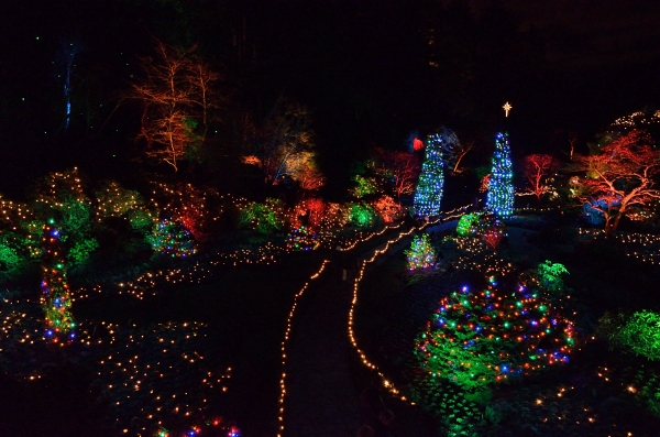 The theme throughout all the gardens was the 12 Days of Christmas, which you begin to discover as you walk around. The theme throughout all the gardens was the 12 Days of Christmas, which you begin to discover as you walk around. 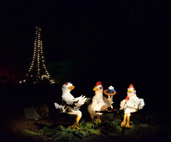 We saw the tree with sparkly pear ornaments… and there was a partridge sitting in it. The two turtle doves were in a small cage… but the three French hens had a bit of whimsy…I won’t bore you with the rendering of the entire song, but we almost missed the four calling birds. We saw the tree with sparkly pear ornaments… and there was a partridge sitting in it. The two turtle doves were in a small cage… but the three French hens had a bit of whimsy…I won’t bore you with the rendering of the entire song, but we almost missed the four calling birds.
I think it was most fun watching little children so excited, with their rosy cheeks and smiling faces. Christmas is about being a kid, no matter how big or how old you are.We wish you all a very Happy Holiday season and a Joyous New Year. |

Hallo, Ich finde den Aufbau der Seite klasse. Macht
weiter so.
I do not even know the way I ended up here, but I thought this put up
used to be good. I do not know who you are but certainly you’re going to a well-known blogger in case you are not already.
Cheers!